


Some thunderstorms with the possibility of becoming severe will ramp up Thursday afternoon and evening in the Northeast. Damaging wind gusts and large hail are the primary threats.
NEW YORK – Thursday evening’s commute for any last-minute Fourth of July travelers along the Interstate 95 corridor could be dampened by a budding threat of severe thunderstorms.
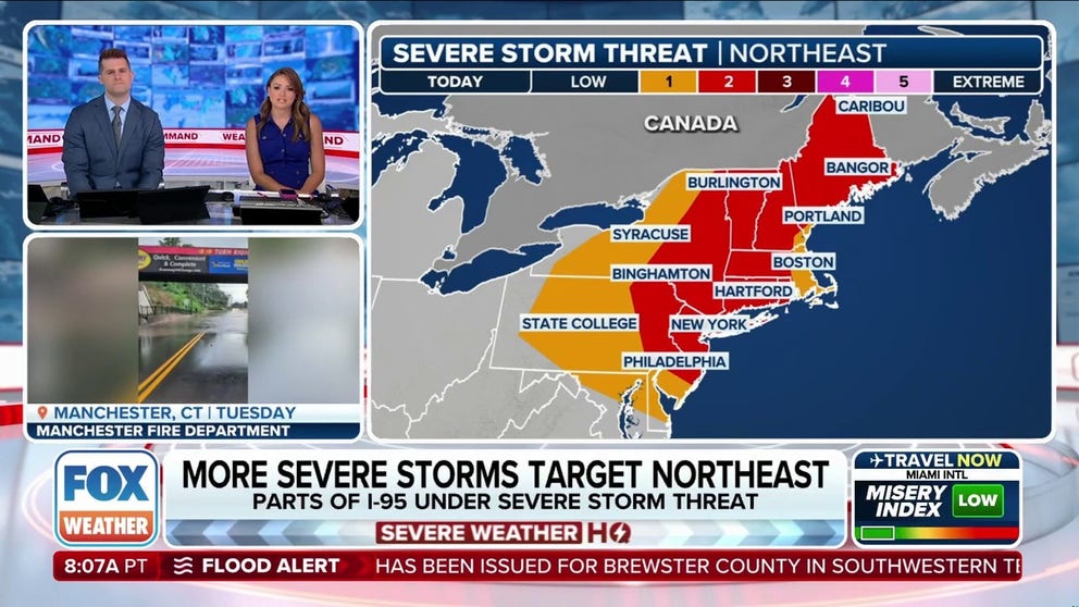
The National Weather Service‘s Storm Prediction Center (SPC) placed much of the Northeast under a Level 2 out of 5 risk for severe weather.


(FOX Weather)
Severe storms were already erupting by late Thursday morning across New England before the threat shifts south toward the I-95 corridor later in the day.
The SPC issued a Severe Thunderstorm Watch covering over 37 million people for portions of Connecticut, Massachusetts, northern New Jersey, southern New York, northeast Pennsylvania, Rhode Island, New Hampshire and Maine until Thursday at 10 p.m. ET.


(FOX Weather)
Areas in the Northeast and New England from Philadelphia to New York City to Boston should be on alert during the afternoon and evening when the storms shift south.
Scattered damaging wind gusts of 50-65 mph and large hail are the primary threats with these thunderstorms.
These storms come on the heels of numerous severe storms that impacted the I-95 corridor at the start of the week, leading to hours-long air travel delays.

Video from Tuesday afternoon showed cars driving through floodwaters in Northeast Philadelphia, Pennsylvania.
Storms started in upstate New York on Thursday morning before moving up into New England.
As the day heats up, storm energy does, too. A belt of stronger winds aloft will increase the wind shear, which, in conjunction with the instability, will allow for some of the thunderstorms to become severe.
WHAT IS WIND SHEAR?

(FOX Weather)
For the I-95 corridor, storms will ramp up around the evening commute but could pop up as soon as 3-4 p.m., according to the FOX Forecast Center.
Flight delays are also possible in Boston and New York City after the evening rush hour.
WHERE RAIN COULD DISRUPT FOURTH OF JULY WEEKEND EVENTS, FIREWORKS AND PARADES


(FOX Weather)
By Friday, things should clear out, making for a nice day across the Northeast and New England.


