


Tropical Storm Chantal is active in the Atlantic, expecting to bring rain to the Carolinas. FOX Weather Storm Specialist Mike Seidel is live in Folly Beach, South Carolina with the latest conditions.
Tropical Storm Chantal formed off the South Carolina coast Saturday morning, prompting Tropical Storm Warnings across parts of South Carolina’s beaches and promising a stormy end to the holiday weekend.
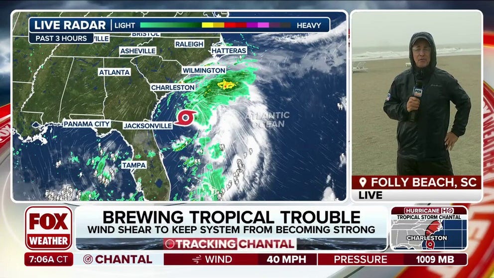
Chantal has peak winds of 40 mph so far and is currently about 150 miles southeast of Charleston, South Carolina, crawling forward to the north at about 2 mph, according to the National Hurricane Center.


(FOX Weather)
The tropical storm is expected to undergo a little more strengthening through the day Saturday before making an expected landfall on the northern South Carolina coast sometime Sunday morning.

(FOX Weather)
Tropical Storm Warnings are in effect from South Santee River, South Carolina to Cape Fear, North Carolina. A Tropical Storm Watch is in effect from Edisto Beach to South Santee River, South Carolina.

(FOX Weather)
HOW TO WATCH FOX WEATHER
Tropical storm-force winds are expected in the warning areas starting Saturday evening and lasting into Sunday morning. Gusts to 40 mph are possible in the watch areas later Saturday.
In addition, heavy rains are across the coastal plains of the Carolinas into Monday, with widespread areas receiving 2-4 inches. Some isolated spots could get up to 6 inches of rain, the NHC says.

(FOX Weather)
Chantal will even bring a minor storm surge to parts of the Carolina coasts.
“The combination of storm surge and tide will cause normally dry areas near the coast to be flooded by rising waters moving inland from the shoreline,” the NHC said.


(FOX Weather)
HURRICANE HUNTERS FLY INTO WORLD’S WORST WEATHER – SEE WHICH STORM WAS THE BUMPIEST
Peak surge could reach about 1-3 feet in the Tropical Storm Warning area, and about 1-2 feet in the watch area.
Heavy surf and life-threatening rip currents will be an added danger for those along the beaches in Chantal’s path.
The Atlantic hurricane season runs from June 1 to Nov. 30.


