


FOX Weather Meteorologist Ari Sarsalari is joined by Jeff Huffman, Weather and GIS Communication Specialist, as the pair break down a nor’easter expected to take shape and rapidly intensify through the weekend. While significant snow in the Carolinas and Virginia look certain, the question still remains if the Northeast will see significant snow.
A nor’easter is expected to develop off of the East Coast this weekend, and likely strengthen into a bomb cyclone that will pack a punch and deliver high winds, harsh winter weather and heavy snow to the coastal Carolinas and Virginia, before tracking north through the weekend.
The FOX Forecast Center is monitoring the development of a powerful nor’easter.
Here’s a day-by-day timeline to follow along with the winter storm.

(FOX Weather)
Friday
Snow will begin during the evening hours Friday, first developing a bit farther west across the Tennessee Valley and the Appalachians.
WEEKEND NOR’EASTER TO BOMB OFF THE EAST COAST, DUMPING HEAVY SNOW IN THE CAROLINAS AND PART OF NEW ENGLAND
Impacts on Friday should remain minimal overall, but light snow is possible in places such as Nashville, Gatlinburg and eventually spreading into parts of Virginia. This phase is more of a lead-in to the main event rather than the core of the storm.
Saturday
It will be a different story by Saturday morning. A coastal low will be in the early stages of development, and snow will rapidly expand across the higher terrain of Virginia, North Carolina, South Carolina and into northern Georgia.
Saturday appears to be the day when the bulk of the snowfall occurs for this region. As the day goes on, the coastal low continues to strengthen, pulling colder air southward while wrapping in increasing amounts of moisture.
Snow intensity is expected to ramp up, especially for interior cities such as Richmond, Raleigh, Charlotte and Columbia, South Carolina.
(FOX Weather)
Snowfall rates could become quite high with efficient snow ratios, and this looks to be an all-day event with very few breaks.
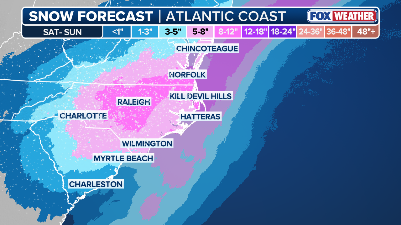
Impacts could range from moderate to very high, particularly if the heaviest snow axis sets up over major population centers. At this point, 8 to 12 inches is on the table, with a bullseye favored somewhere in North Carolina.
MUST-SEE PHOTOS: CRIPPLING ICE IN NASHVILLE DESTROYS POWER LINES, SNAPS TREES DURING CATASTROPHIC WINTER STORM
Even that may be understated, as some guidance suggests this could reach the upper tier of snowstorms. If everything comes together, this could easily rank as a top-five snow event for cities like Raleigh. A wide coverage of 5 to 8 inches is possible for southern Virginia, the bulk of North Carolina and into central South Carolina.

(FOX Weather)
Snow is also likely to reach areas such as Wilmington, Myrtle Beach, Charleston and the Outer Banks.
While the snowfall will understandably grab most of the attention, some of the most serious impacts may occur along the coast. There is growing concern that the combination of 60 to 70 mph onshore wind gusts, high surf and significant beach erosion could lead to scenes reminiscent of impacts seen during the recent hurricane season, including the potential loss of additional homes.
THESE ARE THE BIGGEST ICE STORMS TO EVER IMPACT THE US
If the timing of the heaviest snow overlaps with the strongest winds, blizzard conditions cannot be ruled out, especially along the North Carolina coast. Snow totals will taper closer to the shoreline, but amounts of 3 to 5 inches by Sunday morning appear very possible.
When will the nor’easter undergo bombogenesis?
One of the most notable aspects of this storm is the strong signal for rapid intensification, or “bombing out.”
Bombogenesis occurs when a storm’s central pressure drops at least 24 millibars in 24 hours, and current projections suggest this system could deepen from roughly 1,005 millibars to near 967 millibars between late Saturday and midday Sunday.
(FOX Weather)
WHAT IS BOMBOGENESIS?
That kind of rapid strengthening would create an extremely tight pressure gradient, resulting in powerful winds and dangerous conditions along the immediate coastline, particularly across the Outer Banks.
Sunday
Farther north, the FOX Forecast Center is still keeping a close eye on the potential for nor’easter impacts on Sunday.
Most forecast models agree that the storm will be nearby, but there is still significant disagreement on its exact track. That track will be critical in determining whether the storm has a major impact, only clips the region or stays far enough offshore to limit impacts.
Cities along the I-95 corridor are on the extreme western fringe of the potential impacts. For places like New York City, differences of just 50 to 100 miles in the storm track could mean the difference between minor impacts and more noticeable effects.
At this time, the I-95 corridor from Washington D.C. to New York City is not expecting a blockbuster snowstorm, but some impacts remain possible, mainly in the form of gusty winds and periods of light snow.
ARCTIC PLUNGE: POLAR VORTEX LOCKS IN SNOW, ICE AND LIFE-THREATENING COLD AFTER HISTORIC CROSS-COUNTRY STORM
Farther north, back into Massachusetts and Rhode Island, snow would not be the only concern if the storm tracks closer to the coast.
A stronger system could produce powerful winds along the immediate coastline and over the waters. Wind gusts could exceed 60 mph across the cape and islands, with even higher gusts possible. If these winds coincide with high tide, coastal flooding and beach erosion would become a concern.
HOW TO WATCH FOX WEATHER
If heavy snow aligns with these strong winds, an even higher-impact scenario could unfold, including the potential for blizzard conditions.
(FOX Weather)
SEE IT: COAST GUARD CUTTER FREES NYPD VESSEL FROM ICEBOUND HUDSON RIVER
The range of outcomes remains wide, from a significant coastal storm to a more limited impact scenario.
Stay tuned with the FOX Forecast Center in the coming days, and check back for updates on this developing story.


