


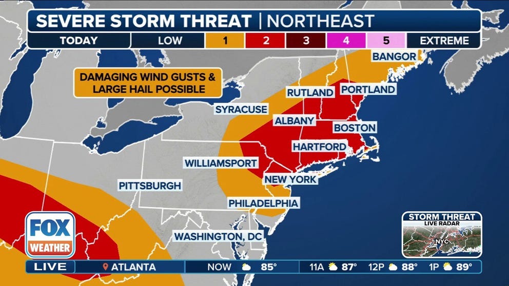
More than 76 million Americans face the threat of severe weather on Sunday from the Northeast to the Midwest. Major cities such as New York, Boston and Indianapolis are included in the higher threat zone for damaging wind gusts.
NEW YORK – The weekend is ending on a stormy note across a large portion of the U.S., as more than 76 million Americans face the threat of severe weather on Sunday from the Northeast to the Midwest.
The three-hour radar loop below shows where showers and thunderstorms are ongoing, along with any severe weather and flood alerts posted by the National Weather Service.
HOW TO WATCH FOX WEATHER


(FOX Weather)
NOAA’s Storm Prediction Center posted a Level 2 out of 5 threat of severe storms for nearly 36 million people, including major cities such as New York, Boston, Indianapolis and Cincinnati.
The threat zone along the Interstate 95 corridor in the Northeast is being fueled by a cold front charging across the region on Sunday afternoon and evening. Damaging wind gusts are the main threat from these storms, but large hail and even a couple of tornadoes are not ruled out.
In the Midwest threat zone, multiple clusters of thunderstorms will pose the threat of damaging wind gusts and perhaps a tornado or two on Sunday afternoon and into Sunday night.
Another area of severe storms is expected in the northern Plains, where damaging winds, hail and a few tornadoes are all potential threats across the Dakotas on Sunday afternoon and evening.


(FOX Weather)
Flash flooding is also a concern on Sunday and Sunday night, particularly from the Midwest and Ohio Valley into the southern Appalachians.
NOAA’s Weather Prediction Center posted a Level 3 out of 4 flood threat in and near central Illinois because the storms in that area are expected to be slow-moving, and the rain will be falling on soils that are already saturated from recent heavy rainfall.
Slow-moving storms will also increase the risk of flash flooding across much of the region covered by a Level 2 out of 4 flood threat from Iowa to Georgia.

(FOX Weather)


