


The first real taste of winter is on the way for millions of Americans as an arctic blast drops temperatures across the Midwest and Northeast. Temperatures could break record lows in the southeast, especially.
The first real glimpse of winter is coming for millions of Americans next week as temperatures drop and a chance for snow rolls in.
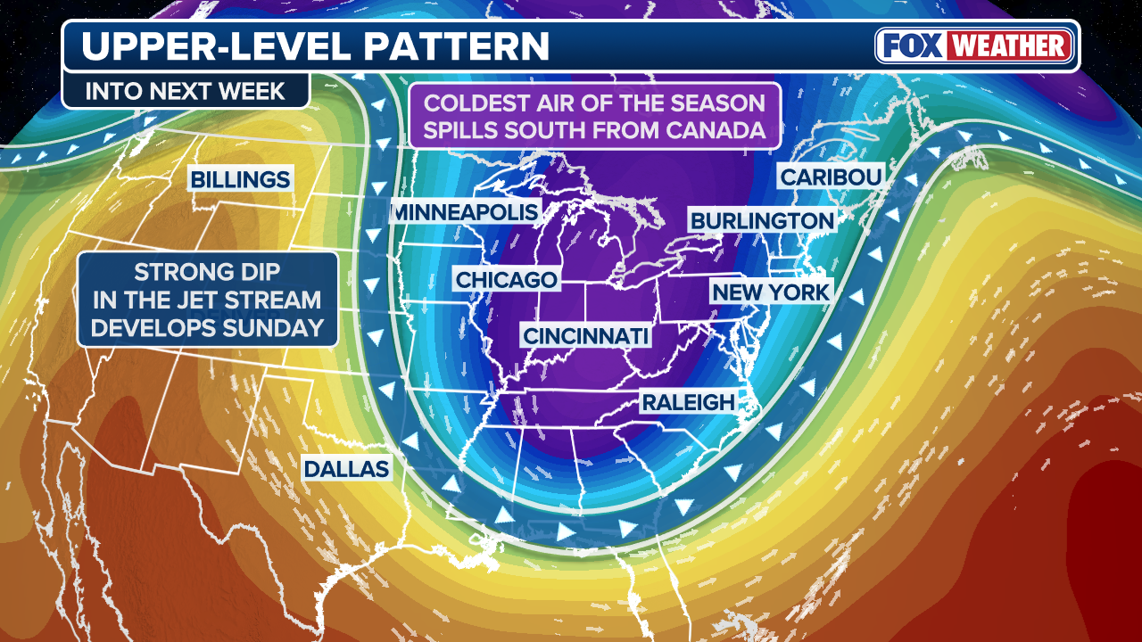
An area of low pressure is expected to move out of Canada as the weekend approaches, ushering in the first taste of a La Niña winter for much of the U.S., according to the FOX Forecast Center.
The La Niña pattern signifies colder temperatures and also tends to bring more frequent Nor’easters along the Eastern Seaboard, which has already seen several coastal storms this fall.
NOAA VS. FARMERS’ ALMANACS: WHOSE WINTER OUTLOOK WILL BE RIGHT?

(FOX Weather)
Cold air from Canada will move south, settling in the Eastern half of the country Sunday and lasting through most of next week.
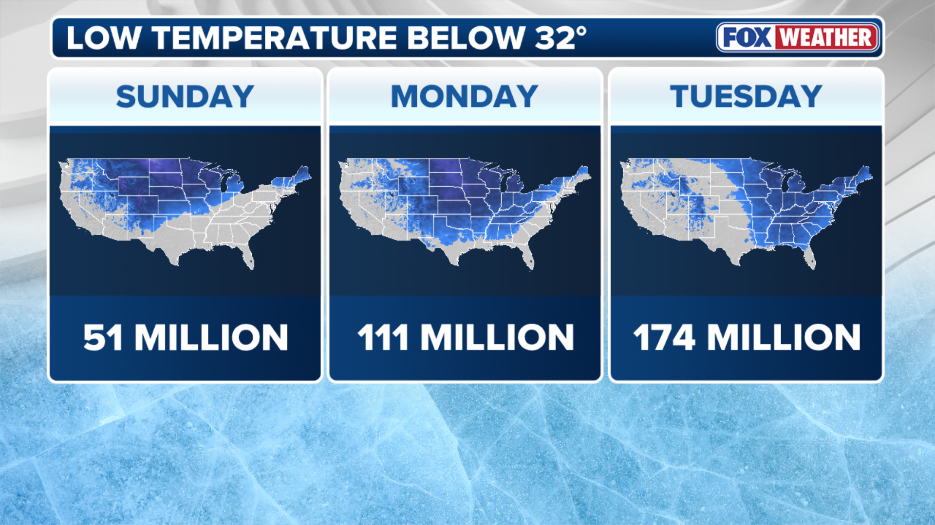
During the night, 170 million Americans across 35 states could see temperatures below freezing, the FOX Forecast Center said.
Those across the Dakotas, Nebraska, Iowa and Minnesota may actually wake up to wind chills in the single digits Sunday morning.
On Monday, cities like Minneapolis, St. Louis, Detroit and Pittsburgh will be waking up to temperatures in the 20s and Atlanta, Dallas, and Nashville will see morning temperatures in the 30s.
WATCH: NEW HAMPSHIRE MOUNTAIN KNOWN FOR ‘WORLD’S WORST WEATHER’ BLASTED WITH 103 MPH WIND GUST CAUGHT ON VIDEO
(FOX Weather)
High temperatures during the day will struggle to rise out of the 30s, the FOX Forecast Center said.
The chilly temperatures move east into the Plains and Appalachian Mountains by Monday, too.
FIRST SNOW OF SEASON THIS YEAR SEEN IN NORTH CAROLINA
Blustery winds between 20-35 mph will make things feel even colder. Wind chills in the interior Northeast are likely to be in the teens.
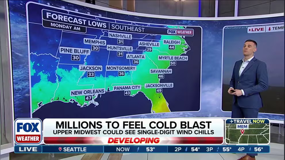
Numerous record lows are possible across the Southeast by Tuesday morning. Some locations across the South are forecast to come close to, tie or break century-old low temperature records on Tuesday morning.

FILE – Bush coated with ice on a cold morning in at the Sunriver Nature Center in Sunriver near Bend, Oregon.
(Wolfgang Kaehler/LightRocket / Getty Images)
Bring on the lake-effect snow
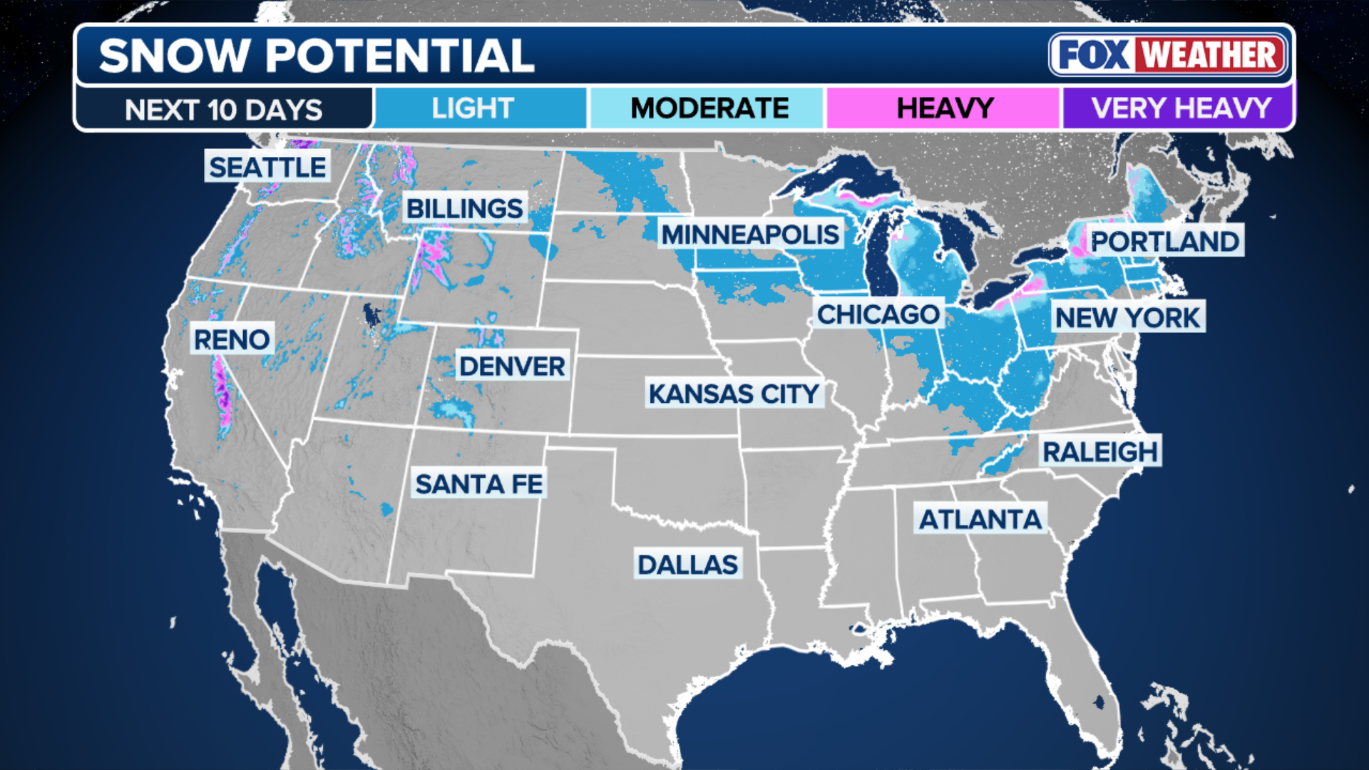
As the cold air from the area of low pressure moves over the relatively warmer waters of the Great Lakes, lake-effect snow will once again return to the forecast, marking the first occurrence of the season for many areas.
Current forecasts show that northerly winds on Monday will lead snow to target northern Indiana, southern Michigan, northern Ohio, and northwestern Pennsylvania.
HOW MUCH WILL IT SNOW ACROSS AMERICA? EARLY FLAKE OUTLOOK FOR BREWING LA NIÑA WINTER

FILE – MINNEAPOLIS, MN. – DECEMBER 2022: A pedestrian walks down Nicollet Mall while high winds kick up snow Thursday, Dec. 22, 2022 in downtown Minneapolis. (Photo by Alex Kormann/Star Tribune via Getty Images)
(Getty Images)
The FOX Forecast Center said the eastern shores of Lakes Michigan, Erie and Ontario are most likely to see snow.
By Tuesday, winds shift to the west, and heavier lake-effect snow bands are expected to impact western Michigan and western New York.
(FOX Weather)
Snow totals along the Great Lakes could accumulate to 5-8 inches with locally higher amounts up to 8-12 inches possible, the FOX Forecast Center said.
The taste of winter will be short-lived as temperatures return back to average by mid-week.


