


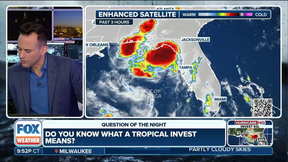
An area of disturbed weather in the tropics is currently over Florida and will soon move into the Gulf. Questions remain on whether the system will organize into a bona fide tropical cyclone.
Mobile, Ala. – The Gulf Coast is bracing for tropical moisture as Invest 93L moved through the Florida Peninsula on Tuesday and threatens to produce heavy rainfall along the Interstate 10 corridor.
An invest is a designation used by the NHC to indicate an area that is under increased scrutiny for the possibility of tropical development.
For the past couple of days, Florida has been the recipient of the heavy rainfall, but the chances of precipitation are moving westward and will impact communities in Alabama, Mississippi and Louisiana through the rest of the workweek.
Because waters in the Gulf are warm and there is enough spin in the atmosphere, the National Hurricane Center has highlighted an area of the eastern and northern Gulf for a medium chance of development into a cyclone. Even if 93L develops into a tropical cyclone the forecast impacts likely won’t change.
Hurricane Hunter aircraft are scheduled to survey the system Wednesday, once the center of circulation is over open water.
BRYAN NORCROSS: WATCHING FOR FLORIDA FLOODING, THEN CHANCE OF DEVELOPMENT IN GULF


(FOX Weather)
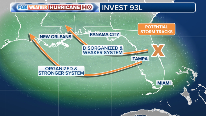
Potential track #1: Center remains over/near land with limited development
Computer models still do not have a good sense as to where the center of circulation may travel, which is common during the infancy stages of a developing tropical cyclone.
One possibility is that the low-level center will travel along the I-10 coastline, limiting cyclone development into a tropical depression or tropical storm, but producing flooding rains and squally conditions along the coast.
According to the FOX Forecast Center, this is the most likely path that the area of disturbed weather could take.
The path would mean heavy rainfall for cities such as Panama City, Mobile and New Orleans.
Already, Flash Flood Watches have been posted for parishes in Louisiana with 3-6 inches of rainfall expected through Friday, with local amounts approaching one foot.
Severe weather such as waterspouts and tornadoes would also be a threat in the stronger cells.

Future potential paths for Invest 93L.
(FOX Weather)
Potential track #2: Center travels over Gulf
A track further out over the Gulf would allow more time for the system to organize, potentially strengthening before landfall.
Under this scenario, rainfall totals along much of the northeastern Gulf Coast would likely be lower – except in the area where the storm ultimately comes ashore, possibly somewhere west of New Orleans.
The FOX Forecast Center noted that the southern path is currently the less likely of the two main forecast tracks, but it remains within the realm of possibility as the system continues to slowly organize.


(FOX Weather)
A stronger system would increase the risk of significant coastal impacts in Louisiana, including higher surf and widespread rip currents throughout the Gulf.
Water temperatures in the Gulf of America are between 85 and 90 degrees Fahrenheit – some of the warmest in the entire basin, providing ample fuel for further development.
All residents along the Gulf Coast are advised to monitor forecasts closely over the next few days whether the system is officially designated as Dexter or not.
Tropical moisture causes problems in Florida
The combination of the state’s daily afternoon thunderstorms and tropical moisture associated with 93L caused problems throughout the Sunshine State, during its brief interaction with the system.
On Saturday, St. Johns County Fire Rescue reported three people were injured Saturday afternoon when lightning struck the St. Augustine Beach Pier.
The agency said one person suffered critical injuries and was airlifted to a trauma center, while another person was taken to a local hospital with non-life-threatening injuries.
A third person was also reported to have been evaluated but refused medical transport.
And further south, east of Tampa, nearly a foot of rain fell within a few hours in Plant City on Monday, causing streets and homes to be flooded.
Local officials did not report any injuries associated with the flash flooding but did characterize the flooding as a 1 out of 1,000-year event.
Most other communities reported seeing rainfall totals in the 1-4″ range, with locally higher amounts.


