


The National Hurricane Center (NHC) says Invest 95L is now likely to become a tropical depression later this week. FOX Weather Meteorologists Haley Meier, Bayne Frone and Michael Estime have the latest on Oct. 5, 2025.
Welcome to the Daily Weather Update from FOX Weather. It’s Sunday, Oct. 5, 2025. Here’s everything you need to know about today’s weather. You can also get a quick briefing of national, regional and local weather whenever you like with the FOX Weather Update podcast.
Invest 95L likely to become tropical depression or Tropical Storm Jerry soon
It’s been an extremely busy period for the tropical Atlantic Basin with the development of hurricanes Imelda and Humberto over the past few weeks, and now the National Hurricane Center (NHC) is keeping its eyes on Invest 95L for possible tropical development.
The NHC says the broad area of low pressure spinning off the Cabo Verde Islands is entering into an area favorable for development, and a tropical depression or Tropical Storm Jerry is likely to form by the middle to end of this week as it approaches parts of the Leeward Islands.


(FOX Weather)
Florida flash flood threat fueled by tropical moisture
After being spared from back-to-back hurricanes, Florida will continue to see the potential for flooding rain through the weekend and to start the workweek as tropical moisture streams toward the Sunshine State.
Former hurricanes Imelda and Humberto have left conditions in the Atlantic ripe for a persistent rainy and windy pattern throughout the Southeast. Tropical moisture and a stalled cold front across Florida will create widespread rainfall and an increased risk of flash flooding.

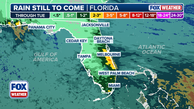
This graphic shows the forecast rain totals in Florida through Tuesday, Oct. 7, 2025.
(FOX Weather)
King Tide event puts Southeast, mid-Atlantic on flood alert
The Southeast and mid-Atlantic coasts are bracing for continued coastal flooding as seasonal King Tides, this month’s Supermoon and persistent onshore flow combine to push coastal water levels higher through midweek.
As a result, numerous weather alerts have been issued in the Southeast and mid-Atlantic, including Coastal Flood Advisories, Coastal Flood Warnings and Rip Current Statements, from the Carolinas through Florida.
The FOX Forecast Center said that the greatest flood threat will occur early this week, but elevated tides will persist into the latter half of the week, too. Conditions should start to improve by mid- to late-week.
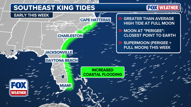
This graphic shows information on threats associated with King Tides along the Southeast and mid-Atlantic coasts.
(FOX Weather)
Photos: Massive debris piles along Outer Banks after 9 homes crumble from rough surf
Piles of debris are being moved from the Outer Banks village of BuxtonNorth Carolina, to a designated spot for removal as rough surf continues to threaten more homes in this unique coastal community threatened by coastal erosion.
Two hurricanes, Imelda and Humberto, passed hundreds of miles offshore from the U.S. East Coast last week, exasperating the rough coastal conditions in North Carolina‘s Dare County, causing nine homes on Hatteras Island to fall into the surf. Click here to see the dramatic photos showing massive debris piles littering the landscape.

Debris from homes washed away by rough surf in Buxton, North Carolina after Hurricane Imelda passed off shore in October 2025.
(Instagram/@b_the_photos / FOX Weather)
Before you go
Here are a few more stories you might find interesting.
Need more weather? Check your local forecast plus 3D radar in the FOX Weather app. You can also watch FOX Weather wherever you go using the FOX Weather app, at FOXWeather.com/live or on your favorite streaming service.


