


A tropical disturbance is being monitored in the Atlantic as the area to watch currently has a low chance of development.
The FOX Forecast Center is monitoring a tropical disturbance in the central tropical Atlantic Ocean, but the system is unlikely to develop into a significant storm that poses a threat to land.
The disturbance, located about 900 miles east-southeast of the Caribbean islands, is producing disorganized showers and thunderstorms as it drifts west-northwestward at 10-15 mph.
As of Sunday, the National Hurricane Center (NHC) gave the disturbance a low chance of becoming a tropical depression or tropical storm within the next seven days.
2025 ATLANTIC HURRICANE SEASON GUIDE: HERE’S WHAT TO KNOW ABOUT THE TROPICS THIS YEAR


(FOX Weather)
“Environmental conditions appear only marginally conducive for development during the next day or so while the system moves west-northwestward at 10 to 15 mph,” NHC forecasters stated in a tropical weather outlook. “By the middle of the week, environmental conditions are forecast to become unfavorable for further development.”
If the system were to organize into a named storm, it would be called Dexter, but computer forecast models show it staying safely away from the U.S. and likely all other landmasses.
A combination of high wind shear and a significant layer of Saharan dust will keep any future system in check and prevent it from organizing into a long-track tropical cyclone.

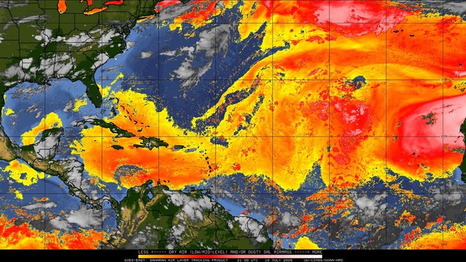
Saharan Air Layer analysis.
(University of Wisconsin-Madison / FOX Weather)
Elsewhere across the Atlantic Basin, there could be a feature closer to the U.S. that deserves greater scrutiny.
Forecasters are keeping an eye on the remnants of Invest 93L, which originated off the coast of Florida and impacted the U.S. Gulf Coast last week.
Some computer forecast models have been indicating that a weak area of low pressure could take a similar path over the remaining days of July.
The NHC has not highlighted the region for development yet, and the chances remain low that a tropical depression or tropical storm will form either in the medium- or long-term future, but it is a possibility that the FOX Forecast Center will be monitoring.
SAVING COASTAL LOUISIANA: A $50 BILLION-5-DECADE-LONG PLAN TO RESTORE MARSHLANDS


(FOX Weather)
A classic example of a circulation leaving the Gulf only to return as a tropical cyclone was Hurricane Ivan back in 2004. However, that system was a powerful hurricane and not a weak disturbance that struggled to even reach tropical depression status.
A return to the Gulf would likely result in heavy rainfall and rough surf, similar to what was experienced during the system’s first pass, but the forecast will continue to be fine-tuned in the coming days.
Outside of the area off the Southeast U.S. coast and the central tropical Atlantic, there are currently no indications that a significant tropical cyclone will develop anytime soon in the Atlantic Basin.
The situation in the Eastern Pacific is a bit different, with at least one significant tropical cyclone potentially forming between now and the end of the month.
As is often the case with tropical storms and hurricanes in that region, systems tend to follow a westward trajectory, usually avoiding direct impacts on Mexico or communities along the Central American coastline.


