


Multiple rounds of rain will soak Northern and Southern California through Christmas week. The latest atmospheric river is blasting the northern part of the state, dropping almost a foot of rain in some places. At least 1 person was killed amid the flooding in Redding, according to the city’s mayor. Heavy rain will persist through Monday over Northern California, including San Francisco and Sacramento. The heaviest rain will shift to Southern California by midweek, just in time for Christmas Eve, as an area of low pressure develops off the California coast.
REDDING, Calif. – Floods turned deadly in Northern California as the latest atmospheric river slammed the region over the weekend, dropping nearly a foot of rain in some places. Meanwhile, more heavy rain and flooding are forecast to persist and expand into Southern California through the Christmas holiday week.
CHRISTMAS WEATHER OUTLOOK: MILLIONS TO SEE ‘NICE’ FORECAST WITH A TOUCH OF ‘NAUGHTY’ ACROSS NATION
The city of Redding saw pockets of widespread flooding Sunday, leaving at least one person dead, according to the mayor. Police and firefighters executed multiple water rescues, as floodwaters forced people from their homes.


Flooding in Redding, California on Sunday, Dec. 21, 2025.
(Redding Police Department/Facebook / FOX Weather)
An Emergency Operations Center and shelters for the displaced are being set up, according to the city’s social media page and Mayor Mike Littau.
MAN DROWNS AFTER CAR IS SWEPT AWAY BY FLOODWATERS IN OREGON
In Humboldt County, Caltrans shut down U.S. Highway 101 in both directions north of Loleta on Sunday, as flooding swamped a significant north-south artery for the West Coast. There’s no word on when that closure will reopen.
The heavy rain halted flights at San Francisco International Airport, snarling holiday travel during one of the busiest air travel days of the year.
More delays are expected at San Francisco International and Los Angeles International Airport on Monday, as this atmospheric river continues to dump heavy rain across the state.

Flooding on U.S. Highway 101 in Humboldt County, California on Sunday, Dec. 21, 2025.
(@CaltransDist1/X / FOX Weather)
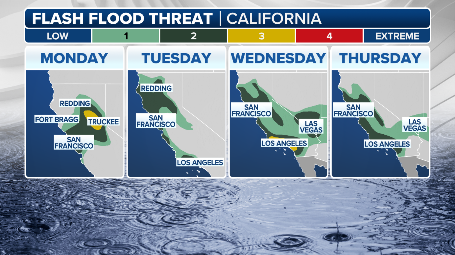
NOAA’s Weather Prediction Center has issued a Level 3 out of 4 flash flood risk for the foothills of the northern Sierra Nevada through Monday.
7 FACTS YOU SHOULD KNOW ABOUT FLASH FLOODS
A broader Level 2 out of 4 flash flood threat covers much of Northern California, including San Francisco.

(FOX Weather)
After a brief reprieve Tuesday, a second round of rain will move into the region Tuesday night, as an area of low pressure develops off the California coast.
The heaviest rain will begin to shift south on Christmas Eve, but the San Francisco metro area should expect 3-5 inches of rain through Friday.
NEWLY TAGGED WHITE SHARK ‘RIPPLE’ MAKES APPEARANCE OFF NEW ORLEANS COAST

(FOX Weather)
According to the FOX Forecast Center, this storm system is expected to intensify as it comes onshore, producing wind gusts up to 80 mph along the coast.
The National Weather Service (NWS) has issued Wind Alerts from Ukiah to Monterey, as well as Bakersfield farther inland, for wind gusts of up to 80 mph through Thursday.
Christmas flood threat for Southern California, Los Angeles
Heavy rain along the Interstate 5 corridor in Southern California beginning Wednesday.
The Los Angeles metro area is under a Level 3 out of 5 risk of flash flooding from Wednesday through Christmas Day morning, with 5-8 inches of rain possible.

(FOX Weather)
According to the FOX Forecast Center, rain rates could approach an inch per hour, threatening areas near burn scars from January’s wildfire disaster with mudslides.
According to the National Weather Service, ash from wildfires creates burn scars – a water-repellent coating that prevents the ground from absorbing water and causes the area to be predisposed to flash flooding and debris flows.
WHAT IS A WILDFIRE BURN SCAR AND HOW COULD THEY HAVE LASTING IMPACTS?
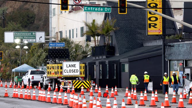
FILE- SANTA MONICA, CA – MARCH 12, 2025 – – Workers walk along Pacific Coast Highway, at Estrada Dr.., minutes before the highway was shutdown in Santa Monica on March 12, 2025. Caltrans closed a segment of Pacific Coast Highway to residents and businesses in burn scar areas at noon Wednesday due to safety concerns from the incoming storm. Only emergency vehicles and U.S. Army Corps of Engineers debris-hauling contractors will be allowed through the closure. (Genaro Molina/Los Angeles Times via Getty Images)
(Getty Images)
All told, this could rank among the city’s wettest Christmas periods on record.
Flood Watches remain in effect for much of the entire state through at least Friday.
Feet of snow expected across Sierra Nevada
Meanwhile, those driving over the Sierras should expect mountain pass closures and hazardous travel conditions beginning Tuesday through Friday.


(FOX Weather)
Feet of snow are expected to fall on the Sierras through the holiday week, with snow levels dropping to 5,000 feet.
Winter Weather Alerts have been issued for the Sierras through Friday.


