


Imelda strengthened into a hurricane Tuesday morning off the Florida’s Atlantic Coast. Hurricane Imelda is bringing swells to the coast of the Southeastern U.S. which can create life-threatening rip currents. Imelda is expected to track towards Bermuda where a Hurricane Watch is in effect.
MIAMI – Hurricane Imelda formed off the southeastern U.S. coast on Tuesday morning, and forecasters say the deadly storm will likely strengthen and could become a Category 2 hurricane as it approaches Bermuda later this week.
And while a landfall in the U.S. is not expected, the effects of Hurricane Imelda are being felt up and down the East Coast from the Southeast through the mid-Atlantic and into the Northeast and New England.

A video shared by FOX Weather Meteorologist Michael Estime shows waves crashing onshore in Melbourne Beach, Florida, as Tropical Storm Imelda spins offshore.
Unfortunately, the impacts of Hurricane Imelda have been deadly.
According to the Volusia County Sheriff’s Office in Florida, a 51-year-old man from “out of state” drowned after he was pulled out into the Atlantic Ocean by a rip current and couldn’t make it back to shore.

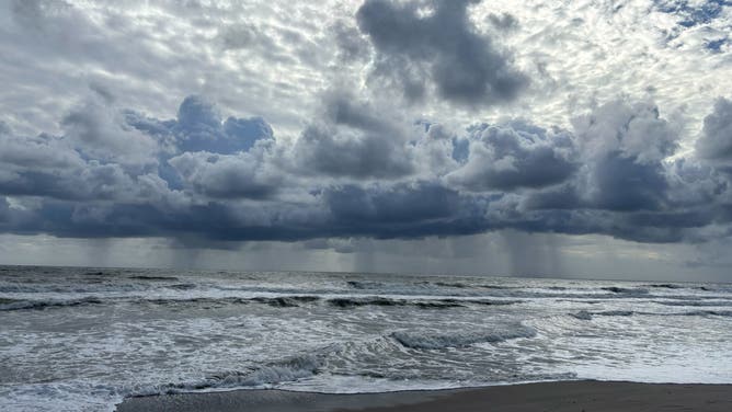
This photo shows the showers off the coast of Melbourne Beach in far outer bands of Imelda.
(Jarrod Maloney/FOX Weather / FOX Weather)
Rip currents are a major concern this week due to Hurricane Imelda, as well as Hurricane Humberto spinning in the Atlantic. Both storms are kicking up massive waves, leading to rip currents at beaches along the East Coast.
In Cuba, a 60-year-old man in Santiago died after torrential rain led to a landslide, causing the man’s home to collapse while he slept, according to local media and first responders.
HOW TO WATCH FOX WEATHER


(FOX Weather)
As of the latest advisory from the National Hurricane Center (NHC), Hurricane Imelda has maximum sustained winds of 75 mph with some higher gusts, and strengthening is likely to continue.
The NHC’s latest forecast has maximum sustained winds forecast to possibly reach 100 mph, making it a Category 2 hurricane on the Saffir-Simpson hurricane wind scale.
DOWNLOAD THE FREE FOX WEATHER APP


(FOX Weather)
The center of Hurricane Imelda is about 755 miles to the west-southwest of Bermuda and is moving off to the northeast at 7 mph.
The NHC said that general motion is expected to continue on Tuesday, followed by a turn toward the east-northeast at a faster forward speed by Tuesday night. On that track, the center of Hurricane Imelda should continue to move away from the Bahamas and quickly approach Bermuda by late Wednesday.

(FOX Weather)
A Hurricane Watch is now in effect for Bermuda, and the NHC said tropical storm conditions could begin to impact the island by Wednesday afternoon, followed by hurricane conditions possibly impacting the island by Wednesday night.
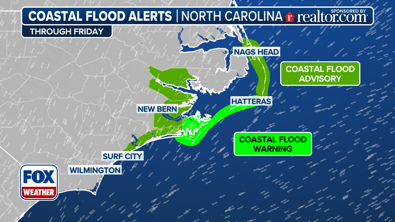
In terms of rainfall, about 1-2 inches of rain is possible, with locally higher amounts of up to 4 inches, across coastal areas of southeastern North Carolina.
That, the NHC said, could result in isolated flash and urban flooding.
As Imelda passes Bermuda, the NHC said 2-4 inches of rain could fall there between Wednesday and Thursday.
(FOX Weather)
In addition to rain, coastal flooding is possible in areas of onshore winds across the southeastern U.S.
That water could reach 1-2 feet above high tide in coastal areas from the Volusia/Brevard County line in Florida northward to the South Santee River in South Carolina.
Swells generated by both Hurricane Imelda and Hurricane Humberto have been impacting the Bahamas and are spreading across much of the U.S. East Coast.
Those swells are leading to life-threatening surf and deadly rip currents.
Imelda blasts Bahamas with flooding rain, gusty winds

A video shared from Dundas Town in the Bahamas shows streets that were flooded due to the torrential rain caused by Tropical Storm Imelda as the storm barreled across the islands on Monday.
Then-Tropical Storm Imelda blasted portions of the Bahamas with gusty winds and flooding rain on Monday.
A video shared from Dundas Town shows streets that were flooded as Imelda moved over the region.
In addition, the Archdiocese of Nassau said all Catholic schools in the Bahamas would be closed Monday due to tropical storm conditions.
“We continue to pray for the safety of everyone affected by the storm,” officials said in a Facebook post. “May God continue to bless and keep you.”
It’s been a busy few weeks in the Atlantic with Hurricane Gabrielle first, and now Hurricane Humberto and Hurricane Imelda are ongoing simultaneously several hundred miles apart.
The Atlantic hurricane season began on June 1 and runs through Nov. 30.


