
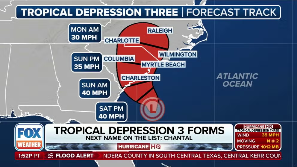
The National Hurricane Center says a broad area of low pressure off the Southeastern coast has officially been designated Tropical Depression Three, which could produce flooding rains along the Carolinas during the next few days.
The National Hurricane Center says a broad area of low pressure off the Southeastern coast has officially been designated Tropical Depression Three, which could produce flooding rains along the Carolinas during the next few days.
The system, previously designated as Invest 92L, is expected to bring tropical downpours to the Southeast Atlantic coast regardless of how strong it becomes.
A Tropical Storm Watch has been issued for some coastal communities in South Carolina, ahead of the system’s impacts, which is expected to become Chantal over the next 24 hours.
The NHC has issued alerts from Edisto Beach, South Carolina to Little River Inlet, South Carolina, with a landfall anticipated on
HURRICANE HUNTERS FLY INTO WORLD’S WORST WEATHER. SEE WHICH STORM WAS THE BUMPIEST
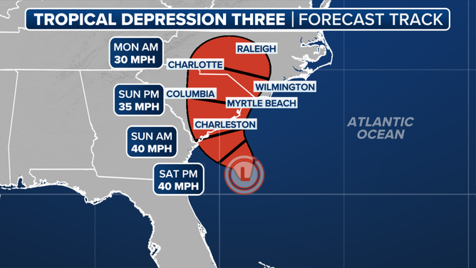
Tropical Depression 3 forecast track
(FOX Weather)
Pockets of 5-plus-inch rainfall have already occurred across Florida and coastal Georgia and the Carolinas. Significant additional rainfall is expected into next week, especially in eastern North Carolina.
Hurricane Hunter aircraft investigated the system on Friday and determined it had gained enough organization to be classified as a tropical depression.
Due to the system’s limited time over water, the cyclone is not expected to strengthen more than a minimal tropical storm with winds of between 40-50 mph.
Once landfall occurs, the system is only expected to slowly decay while over the Carolinas.
The Tropical Storm Watch does include Charleston, Georgetown and Myrtle Beach and will likely be upgraded to a Tropical Storm Warning as the event gets closer in time.
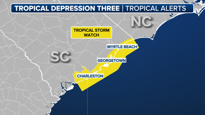
Tropical Storm Watch map
(FOX Weather)
Chantal would be the third named storm of the season, which usually doesn’t happen until early August.
“Interests elsewhere along the southeast coast of the United States should monitor the progress of this system. Additional warnings and watches will likely be required for portions of this area later tonight and Saturday,” the NHC stated.

(FOX Weather)