
FOX Weather Meteorologists Steve Bender and Ari Sarsalari break down the latest updates on the significant severe weather outbreak across the U.S., as Virginia is now under a tornado warning.
WASHINGTON — A sprawling line of severe thunderstorms that slammed the Heartland Sunday made its way east Monday, placing more than 12 million people across parts of the Mid-Atlantic and the Southeast under a rare Level 3 out of 5 risk of severe weather.
LIVE UPDATES: RARE SEVERE STORM OUTBREAK TARGETS EAST COAST, HISTORIC BLIZZARD PARALYZES THE MIDWEST
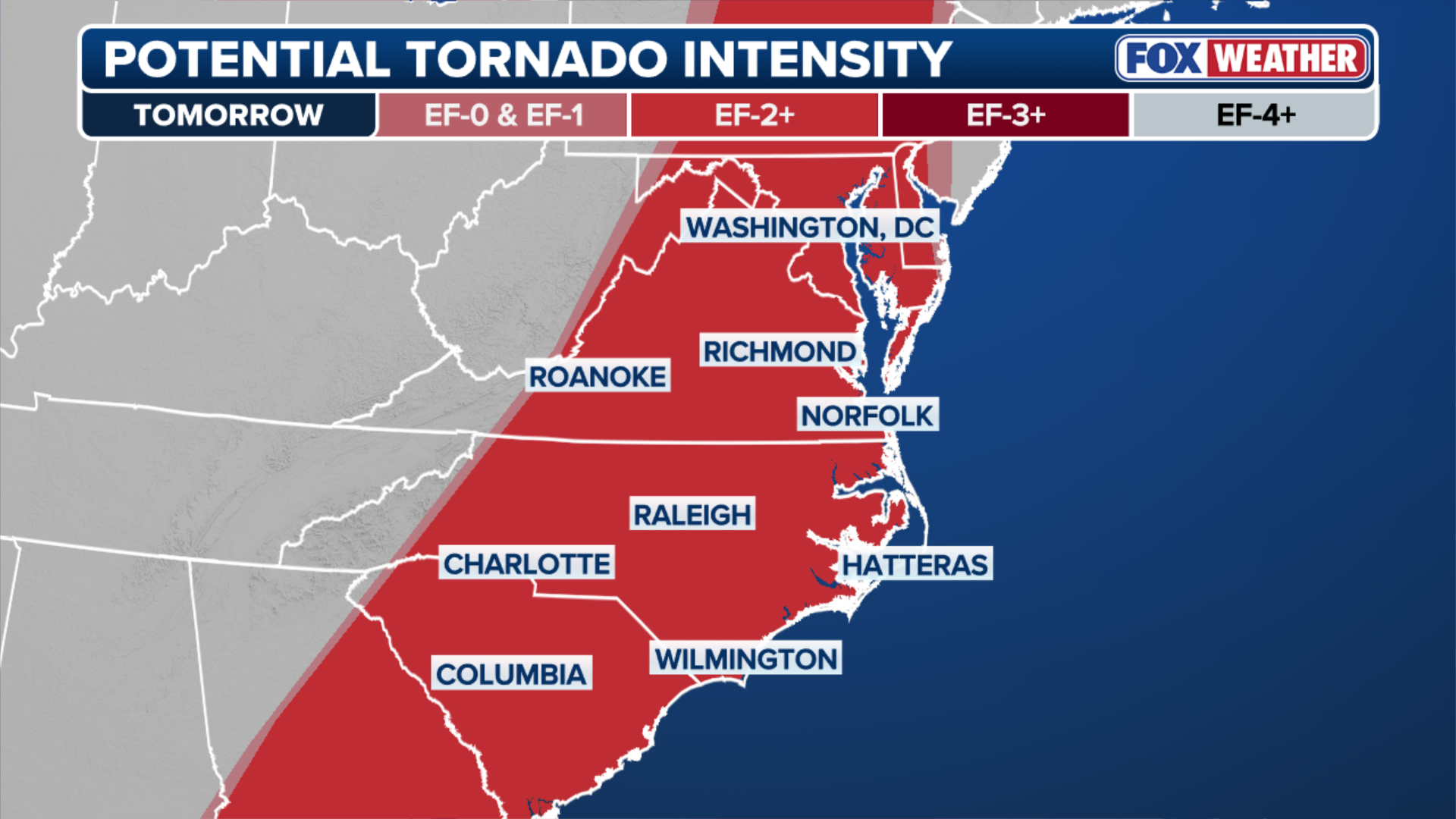
Widespread wind gusts approaching hurricane-force and storms were capable of producing strong, long-track EF-2+ tornadoes across parts of the Carolinas, north through Virginia, Maryland and Washington, D.C.
The National Weather Service downgraded the severe weather threat to Level 3/5, and a Tornado Watch issued for the Washington, D.C., area was canceled.
A Severe Thunderstorm Watch was issued late Monday night, with a warning in effect for the Washington, D.C. area. Wind gusts topped 60 mph, according to the FOX Forecast Center.
LIFE-THREATENING BOMB CYCLONE BLIZZARD RAPIDLY INTENSIFIES AS EXTREME SNOW, WHITEOUT CONDITIONS SLAM MILLIONS

(FOX Weather)
The severe storms were driven by a cold front pushing across the eastern U.S.
Tornado Watches and Tornado Warnings were in place for parts of Georgia and the Florida panhandle early Monday. At one point, a Severe Thunderstorm Warning triggered a ground stop at Atlanta’s Hartsfield-Jackson International Airport.
WHAT IS A SQUALL LINE AND WHY IS THIS TYPE OF SEVERE WEATHER SO DANGEROUS?
Severe storms were most active across the Southeast Monday morning. The main threat shifted to the Carolinas and Mid-Atlantic later in the day.
FOX News Chief Congressional Correspondent Chad Pergram joins FOX Weather to talk about the impact of an ongoing severe weather threat in Washington, D.C.
NOAA’s Storm Prediction Center issued a 15% risk of tornadoes for a corridor from Washington, D.C., south through parts of central and Eastern Virginia, as well as central North Carolina, including Raleigh, and north-central South Carolina.
Washington, D.C. schools were dismissed two hours early due to the threat.
TORNADO SAFETY: THE SAFEST AREAS TO PROTECT YOURSELF AND WHY TO AVOID OVERPASSES
(FOX Weather)
These tornadoes had the potential to be EF-2 or stronger and to be long-track tornadoes, according to the Storm Prediction Center.

This graphic shows potential wind intensity Monday.
BITTER ARCTIC COLD BLAST TO IMPACT OVER 200 MILLION AMERICANS IMMEDIATELY AFTER MONSTROUS BOMB CYCLONE
Additionally, these storms were expected to produce damaging wind gusts between 60 and 80 mph, which can easily damage structures and cause widespread power outages.
The threat slowly faded through Monday evening as severe storms moved off the coast, but very cold temperatures will move in quickly behind them, creating dangerous conditions for those who lose power.