
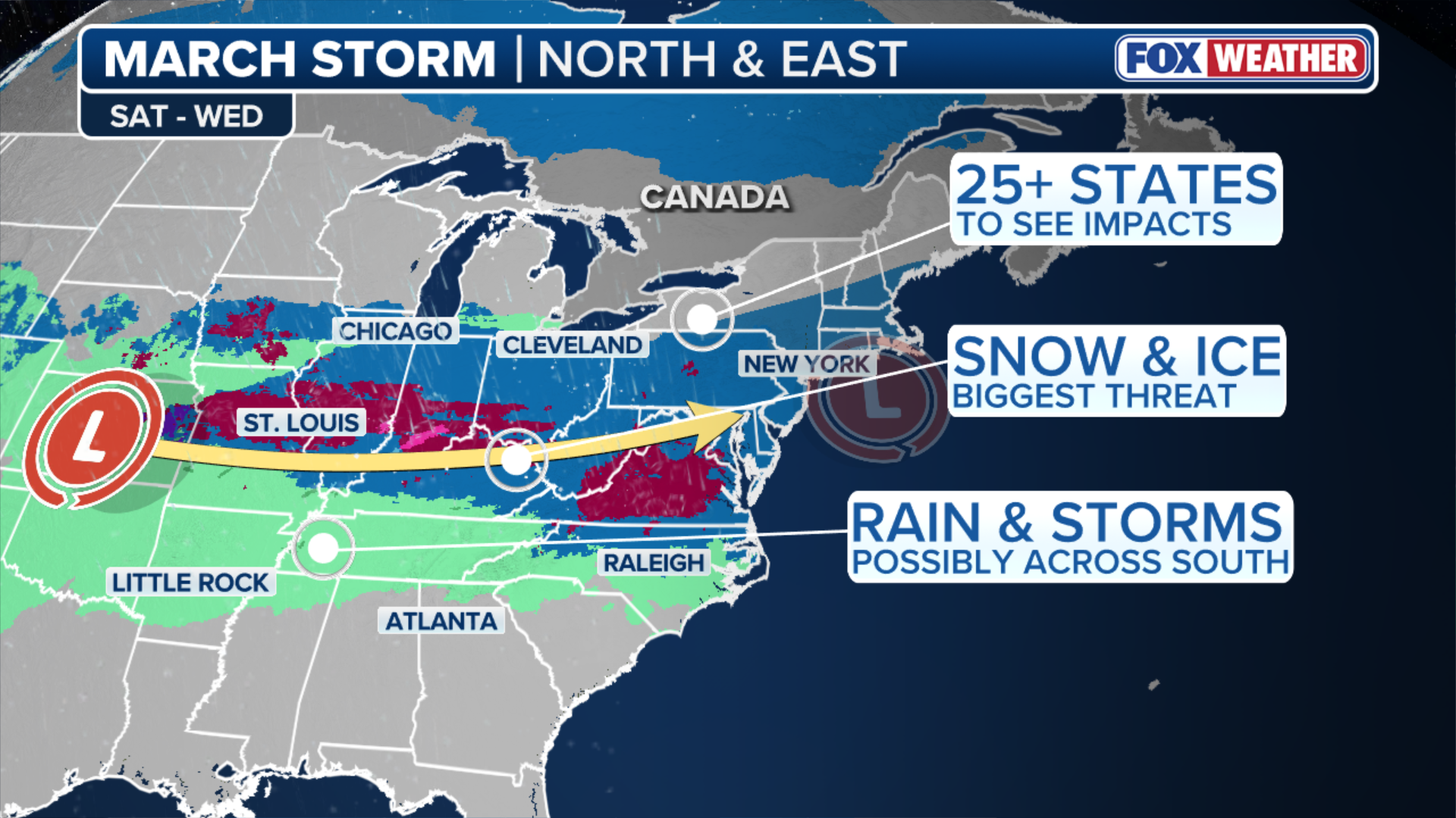
Just one week after a historic blizzard pummeled New England and other parts of the Interstate 95 corridor, yet another potential multi-day winter storm could impact millions across 25 states in the Northeast, as well as the Midwest beginning Sunday.
Just one week after a historic blizzard pummeled New England and other parts of the Interstate 95 corridor, yet another potential multi-day winter storm could impact millions across 25 states in the Northeast, as well as the Midwest beginning Sunday.
MARCH WEATHER OUTLOOK: WARMER TEMPERATURES, SEVERE STORM THREATS ON THE HORIZON AS WE SPRING INTO NEXT MONTH

Strong winds and heavy snow pound Somers Point, NJ, amid Feb. 2026 blizzard
(Zach Blum / FOX Weather)
While another complicated atmospheric setup has prevented computer forecast models from determining the exact impacts, two general scenarios have emerged.
REPORT HIGHLIGHTS NEW DETAILS ABOUT DEADLY AVALANCHE IN SIERRA NEVADA
According to the FOX Forecast Center, if key forecast ingredients come together, a swath of 6–8 inches of snow would coat a corridor from the Ohio Valley to portions of the coast along I-95.
Meanwhile, low-end projections favor a swath of 1–3 inches of snow in the same region with more mixing of ice and rain.
(FOX Weather)
The setup begins on Saturday, when a shot of cold air settles across the northern third of the country, which is necessary for significant snowfall.
5 INJURED AND LOCAL HIGH SCHOOL EVACUATED AFTER GRASS FIRE ERUPTS IN COLORADO
By Sunday, a weak disturbance will emerge from the Rockies which will increase southerly winds a few thousand feet above the surface. Those winds will funnel warmer air northward, where it will ride over the cold, dense air already in place.
This will allow for precipitation, which could fall as snow, sleet, freezing rain, or plain rain depending on how much cold air is present — a phenomenon meteorologists call “overrunning.”

(FOX Weather)
Exactly where the snow-rain line will set up still remains something of an open question.
Freezing rain and sleet are expected to create dangerous road conditions within that transition zone. Based on current data, the greatest icing concern is centered along the Interstate 70 corridor and through the Ohio River Valley.
HURRICANE MELISSA TIES RECORD FOR STRONGEST HURRICANE IN ATLANTIC HISTORY

Someone marveling at the amount of snow in Brooklyn, NY.
(Jolie / FOX Weather)
According to the latest forecast models, snow and some mixed precipitation will break out across parts of the Midwest Sunday and reach the Ohio Valley sometime Monday before eventually making its way to the Northeast coast.
The exact impact of this system will become clearer through the week.
Check back for updates on this developing story.