

More than 200 million people across more than 35 states, from New Mexico to New York, are in the path of a potentially historic winter storm that’s expected to extend over 2,000 miles and deliver crippling snow and ice, beginning Friday. A trailing blast of Arctic air associated with the polar vortex is expected to bring a dangerous re-freeze that could create long-duration power outages and paralyze travel for days.
Fast Facts:
- Crippling ice expected across a corridor from Texas to the Carolinas
- High-impact snowstorm headed for the Northeast
- Thousands of flights likely to be canceled
More than 200 million people across more than 35 states, from New Mexico to New York, are in the path of a potentially historic winter storm that’s expected to extend over 2,000 miles and deliver crippling snow and ice, beginning Friday.
A trailing blast of Arctic air associated with the polar vortex is expected to bring a dangerous re-freeze that could create long-duration power outages and paralyze travel for days.
LIVE UPDATES: EXTREME WINTER STORM DEVELOPING, THREATENING 35+ STATES WITH HEAVY SNOW, CRIPPLING ICE
Texas, North Carolina, South Carolina and now Georgia have all declared states of emergency ahead of the sprawling system as some energy companies have begun to mobilize additional crews, preparing for ice accretion capable of taking down power lines and creating nearly impossible driving conditions.
(FOX Weather)
Meanwhile, states along the Mid-Atlantic and Northeast portions of the Interstate 95 corridor are preparing for the potential for more than a foot of snow, in what could be the biggest snowstorm in years.
The sprawling system will move out of the Southwest beginning Friday morning and track east through the weekend — first slamming Texas and Oklahoma, before raking across the South and into the Mississippi and Tennessee valleys, and eventually reaching the Mid-Atlantic and Northeast coasts.
WHAT IS THE JET STREAM?
Airports across the country will likely see days of significant cancellations and delays.

(FOX Weather)
States prepare for potentially historic storm
Georgia Governor Brian Kemp declared a state of emergency Thursday morning, effective through next Tuesday ahead of the storm.
Texas activated its state emergency response resources on Wednesday. Governor Greg Abbott said this would ensure municipalities have critical resources before any potential winter weather impacts.
HOW TO WATCH FOX WEATHER
South Carolina enacted its Emergency Operations Plan, which allows state agencies to quickly mobilize resources, and allows the state National Guard to activate personnel and prepare equipment.
In North Carolina, Governor Josh Stein said the state’s emergency response team is already working to make sure resources are in place to keep residents safe.
Maryland has also declared a state of preparedness in anticipation of the storm.
Dangerous ice storm targets Southern Tier
A paralyzing ice storm is expected to be the main threat within the southern component of this colossal winter system.
SOUTHERN CITY COULD SEE A TOP FIVE WORST SNOWSTORM IN RECORDED HISTORY FROM BREWING MAJOR WINTER STORM
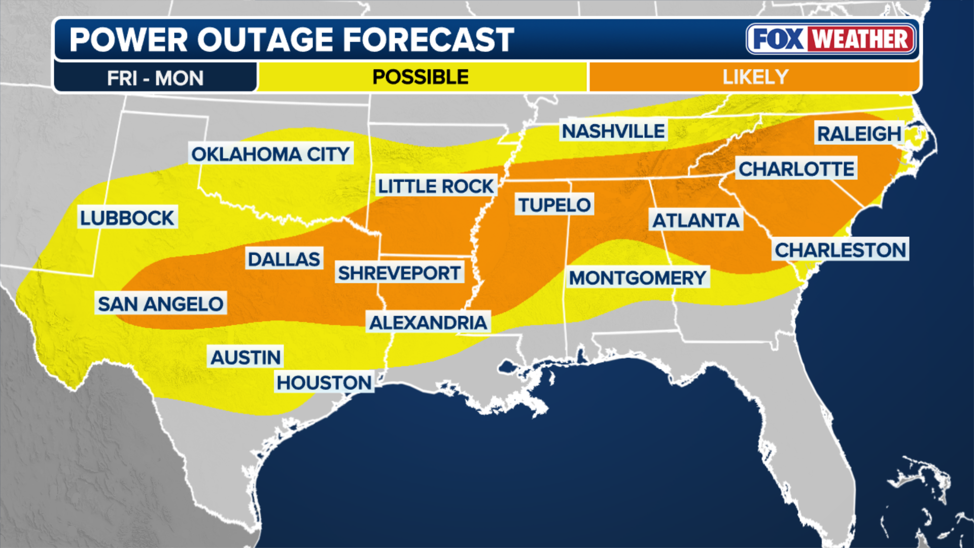
Over 15 states stretching across a massive corridor from New Mexico through the South to the Carolinas and Mid-Atlantic coasts could see ice accretion capable of causing numerous power outages from Friday through Monday.

(FOX Weather)
The bull’s-eye for the most significant ice accretion, capable of causing widespread power outages, is currently forecast from East Texas to southern Arkansas and northern Louisiana, through to northern Mississippi.
POTENTIAL HISTORIC WINTER STORM TRACKER: LIVE RADAR, FORECASTS FOR SNOW, ICE WITH ACTIVE WINTER WEATHER ALERTS
Those in the Dallas-Fort Worth metro area should also prepare for hazardous ice beginning Friday.
Another significant ice threat is forecast to develop across the eastern side of the Appalachians, currently including Atlanta, Augusta, Georgia and Charlotte, North Carolina.
(FOX Weather)
Winter system to blast Southern Plains Friday, nearly impossible travel conditions Saturday
Cold rain will break out from Dallas to Little Rock, Arkansas, by Friday afternoon, before transitioning over to a dangerous wintry mix by Friday evening.
The worst of the storm is expected Saturday morning through the day, with widespread icing from Midland, Texas through Dallas and into Little Rock, persisting into Monday.
SEE LATEST: SOUTHERN CITY COULD SEE A TOP FIVE WORST SNOWSTORM IN RECORDED HISTORY FROM BREWING MAJOR WINTER STORM
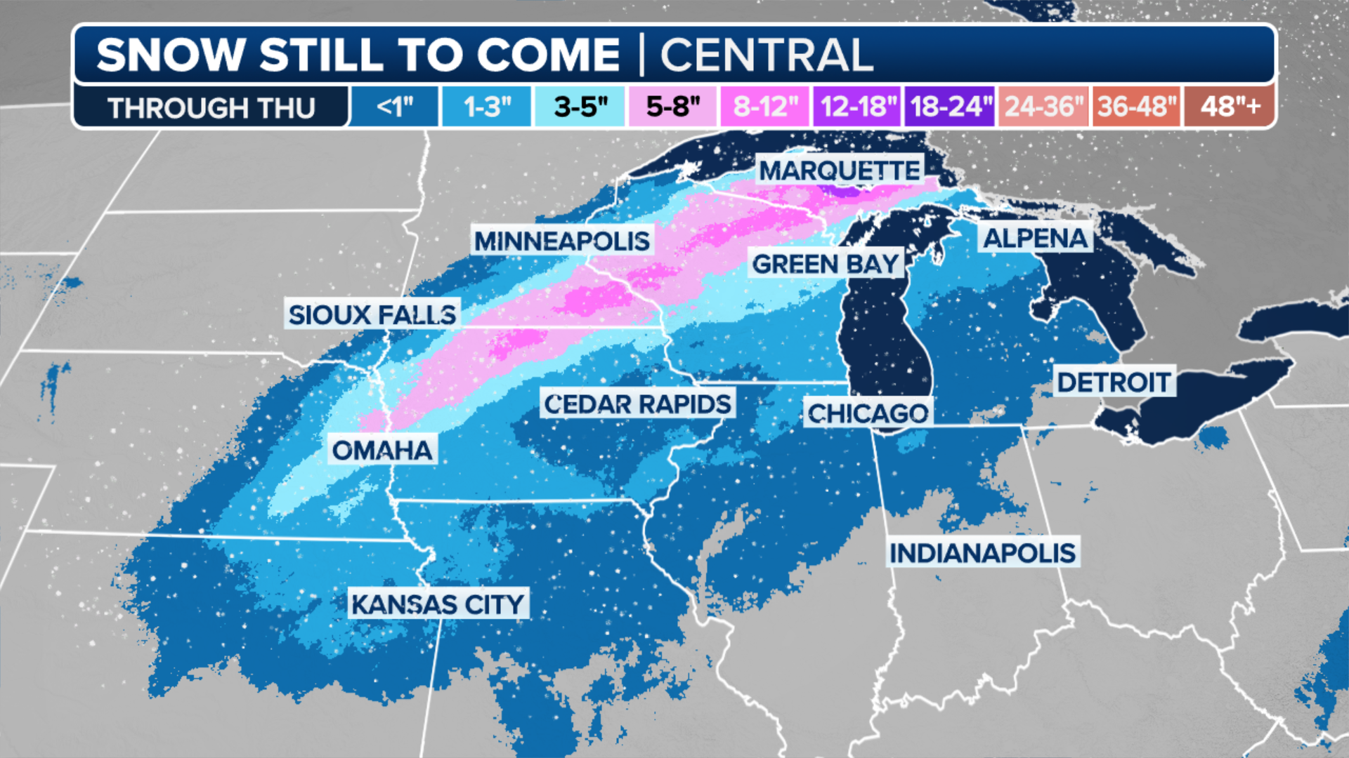
Snow is expected to blanket an area from the Texas Panhandle north into Kansas and Missouri, with the heaviest snow expected between Interstates 70 and 40.
(FOX Weather)
A wide swath of 5 to 8 inches of snow is expected across central Oklahoma into northern Arkansas through Sunday, including the Wichita, Kansas, Oklahoma City, Tulsa and Kansas City, Missouri metro areas, with flakes even reaching Chicago.
This system has the potential to break into the top five largest snow events in Oklahoma City history.
POLAR VORTEX LOCKS IN OVER MOST OF US, DAYS OF ARCTIC TEMPERATURES AHEAD FOR MILLIONS THROUGH JANUARY

(FOX Weather)
As the storm tracks into the Southeast, a deep freeze will remain over the Southern Plains preventing snow and ice from melting, potentially hindering any power restoration efforts.
System reaches the Southeast Saturday, ice threat along I-40 and I-20
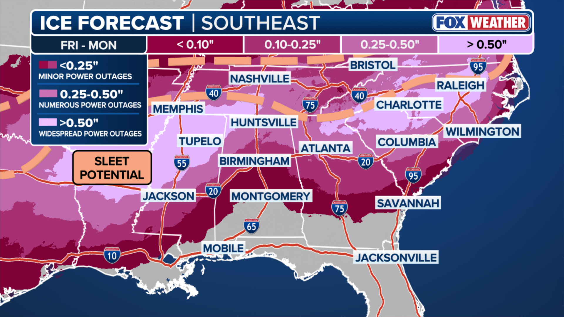
The massive system will reach the Southeast by Saturday morning, when a very strong area of high pressure will be positioned to the north across the Northern Plains and Midwest.
This high, rotating clockwise, will funnel arctic air southward, locking it against the Appalachians, setting the stage for dangerous icing from Atlanta to Charlotte, North Carolina.
SEE LATEST: CRIPPLING WINTER STORM TO DELIVER DANGEROUS ICE ACROSS MASSIVE SWATH OF SOUTHEAST, THREATENING POWER GRIDS
Significant ice accumulations are also expected across northern Alabama and West Tennessee. Farther south, dangerous driving conditions are expected across Interstate 20.
(FOX Weather)
Some uncertainty remains regarding exactly where freezing rain will develop versus sleet, which is significantly less damaging to the power grid.
The storm overall has shifted farther north from forecasts earlier in the week, meaning that significant snow will be confined north of I-40, with I-40 itself likely to see periods of nearly impossible driving conditions due to icing.
PARTS OF LOWER 48 COLDER THAN ALASKA THIS WEEK AS POLAR VORTEX SET TO GRIP NATION WITH WEEKS OF ARCTIC AIR
The heaviest snow is expected along Tennessee’s Cumberland Plateau and potentially into the southern Appalachians in western North Carolina. Kentucky will see 5-8 inches of snow statewide with localized pockets up to a foot.
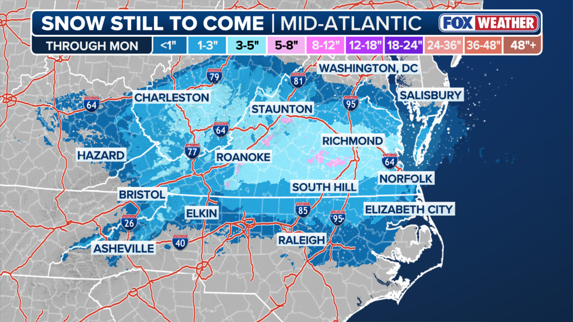
Biggest snowstorm in years forecast for Mid-Atlantic and Northeast
Meanwhile, there’s growing confidence among computer forecast models that this system could develop into the most significant snowstorm for parts of the Mid-Atlantic and New York tri-state area in years.
(FOX Weather)
There’s increasing likelihood that the massive winter storm will merge with a disturbance out of the Northern Plains and create an even more powerful system off the East Coast.
WHAT ARE COLD WEATHER ALERTS?
If this scenario plays out, Philadelphia, New Jersey and New York City could see more than a foot of snow by Monday morning.
The precise interaction between these two systems will determine whether snow totals land closer to 8 inches or 16 inches.
The storm will reach the region by Saturday night and peak through the day Sunday before finally relenting Monday.

(FOX Weather)
Currently, the highest snow accumulations are forecast to fall across parts of central Virginia through Washington, D.C.
The farther north the storm is able to track, the greater the likelihood of significant snow further north along the I-95 corridor in New England, including Boston.
Ahead of the storm, Winter Storm Watches and Warnings have been expanded through the Mississippi and Ohio valleys and into Pennsylvania, New Jersey and New York beginning Friday night through Sunday.
Check back for updates on this developing story.