Close Menu

    Subscribe to Updates

    Get the latest creative news from FooBar about art, design and business.

    What's Hot

    Grizzlies rehire Darnell Lazare to develop bigs

    July 26, 2025

    Bryan Norcross: We’ll likely have an Atlantic disturbance to follow next week

    July 26, 2025

    KDH: Slovakia is accumulating debt the fastest in the EU, the government cannot do anything about it

    July 26, 2025
    Facebook X (Twitter) Instagram
    Facebook X (Twitter) Instagram Vimeo
    Daily Western
    Subscribe Login
    • Western News
      • Culture
      • Politics
      • Economy
    • Sports
      • Football
      • basketball
    • Weather
    Daily Western
    • Home
    • About Us
    • Contact Us
    • Privacy Policy
    Home»Weather»Bryan Norcross: We’ll likely have an Atlantic disturbance to follow next week
    Weather

    Bryan Norcross: We’ll likely have an Atlantic disturbance to follow next week

    DailyWesternBy DailyWesternJuly 26, 2025No Comments3 Mins Read
    Facebook Twitter Pinterest LinkedIn Tumblr WhatsApp VKontakte Email
    Bryan Norcross: We’ll likely have an Atlantic disturbance to follow next week
    Share
    Facebook Twitter LinkedIn Pinterest Email


    Three areas to watch have been designated in the eastern Pacific while long range models hint the Atlantic basin may be starting to awaken.

    Three areas to watch have been designated in the eastern Pacific while long range models hint the Atlantic basin may be starting to awaken.

    Computer forecasts continue to indicate that a fairly robust disturbance will move off Africa about Monday. The track is forecast to be far enough south that it won’t immediately plow into the Saharan dust. There is a reasonable consensus in the various long-range models that the disturbance will track across the Atlantic and be in the vicinity of the northeast Caribbean late in the week.

    None of the current projections shows a storm of any significance when the system is near the Caribbean. It will have run a gauntlet of intruding Saharan dust, dry air, and only marginally conducive upper-level winds on its trek west.

    Bryan Norcross: We'll likely have an Atlantic disturbance to follow next week

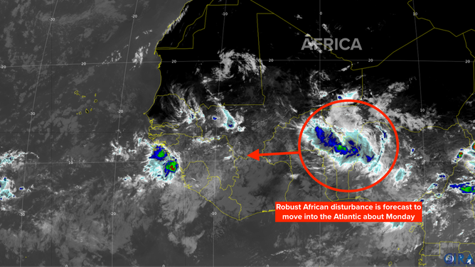
    If it survives with some sort of circulation intact late in the week, there is some evidence that the overall atmospheric pattern will become more conducive for storm development. The long-range computer forecasts that predict an organized system forming—both the traditional forecasts and the new AI models—generally show a track curving near or east of the Bahamas and off the East Coast of the U.S.

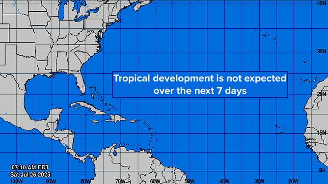
    The odds of this happening are still in the low range, but the possibility is interesting because this is the first time that long-range projections have shown a disturbance getting far enough across the Atlantic to potentially develop into a storm. We’ll see what happens over the next several days. Remember, the rule: Forecasts for systems that are just developing or are disorganized are subject to larger errors and will often change. This system hasn’t even emerged from the African coast, so there’s a long way to go. The National Hurricane Center is not predicting any development over the next 7 days, so we’re talking about more than a week from now before anything might happen.

    Tropics Info

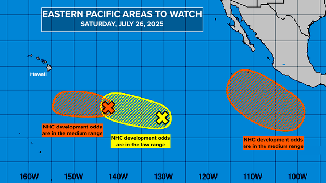
    Evidence from the Pacific

    The National Hurricane Center has three areas to watch in the eastern Pacific. Each one has a decent chance of developing into at least a tropical depression, and computer model forecasts indicate a good chance they’ll evolve into named storms. Two of the systems look to track south of Hawaii, and the third, parallel to the Mexican coast.

    Over the next few weeks, a number of computer forecasts are predicting multiple eastern Pacific storms.

    The possible tie to Atlantic storm development is related to the phenomenon called the MJO. The MJO is a large-scale pulse that slowly revolves around the Earth, alternately suppressing and enhancing storm development. Over the next week or so, forecasts predict that the enhancing phase will cross the eastern Pacific. This might be responsible for the predicted outbreak of organized storms.

    Tropics Info

    If the MJO pulse continues moving east as predicted, it would move over the Atlantic from west to east through the first part of August. This would, broadly speaking, make the atmospheric pattern across the tropics more conducive for development. This MJO forecast adds a little credence to the idea that the Atlantic disturbance might be more inclined to develop a week or 10 days from now.

    None of this is surprising, of course. On average, the odds of storm development increase in August and dramatically increase after August 15.
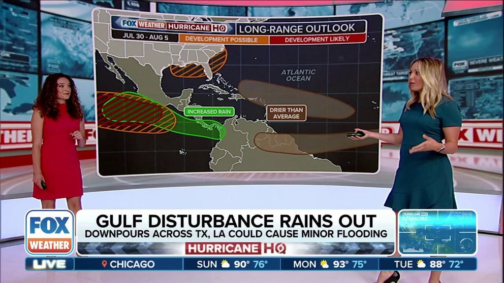
    In the Gulf

    The disturbance we watched track across the northern Gulf has died out, but the moisture lingers from Mississippi to East Texas. Tropical downpours causing local flooding are still possible. Stay aware.

    The moisture should move out after the weekend, but extreme heat will move in. The combination of heat and humidity will likely push the feels-like temperature into the 110°F range. Stay cool.

    Atlantic Bryan disturbance follow Norcross Week
    Share. Facebook Twitter Pinterest LinkedIn Tumblr WhatsApp Email
    Previous ArticleKDH: Slovakia is accumulating debt the fastest in the EU, the government cannot do anything about it
    Next Article Grizzlies rehire Darnell Lazare to develop bigs
    DailyWestern
    • Website

    Related Posts

    Tropical cyclones, monsoon rains leave dozens dead in Philippines

    July 26, 2025

    Why is San Francisco having its coldest summer in decades?

    July 26, 2025

    Bryan Norcross: The Gulf disturbance’s last chance and first live hurricane Q&A of the season

    July 25, 2025

    Flash flooding impacts burn scar areas in southern New Mexico

    July 25, 2025
    Leave A Reply Cancel Reply

    Demo
    Our Picks
    • Facebook
    • Twitter
    • Pinterest
    • Instagram
    • YouTube
    • Vimeo
    Don't Miss
    basketball

    Grizzlies rehire Darnell Lazare to develop bigs

    By DailyWesternJuly 26, 20250

    According to Drew Hill of The Daily Memphian, the Memphis Grizzlies have announced the addition…

    Bryan Norcross: We’ll likely have an Atlantic disturbance to follow next week

    July 26, 2025

    KDH: Slovakia is accumulating debt the fastest in the EU, the government cannot do anything about it

    July 26, 2025

    Price Controls on Oranges – Econlib

    July 26, 2025

    Subscribe to Updates

    Get the latest creative news from SmartMag about art & design.

    About Us
    About Us

    Welcome to Dailywestern.news your reliable source for real-time updates on Western affairs, sports highlights, and global weather insights.

    Our Picks

    Ro Khanna on Elon Musk, Donald Trump, and China

    June 5, 2025

    How the Trump-backed policy bill rolls back Obamacare

    June 5, 2025

    Greg Mankiw’s Blog: Stanley Fischer

    June 5, 2025
    New Comments
      Facebook X (Twitter) Instagram Pinterest
      • Home
      • About Us
      • Contact Us
      • Privacy Policy
      © 2025. All Rights Reserved by Dailywestern.

      Type above and press Enter to search. Press Esc to cancel.

      Sign In or Register

      Welcome Back!

      Login to your account below.

      Lost password?