

FOX Weather is your Hurricane HQ
(FOX Weather)
Updated at 9:30 a.m. ET on Wednesday, Sept. 17, 2025
The tropical disturbance we’ve been following in the central tropical Atlantic has been upgraded to Tropical Depression Seven. The system is still fighting the dust and dry air, but the National Hurricane Center deemed its circulation sufficiently well-developed to classify the system a depression. You can see the dusty air impacting the west side of the elongated circulation.
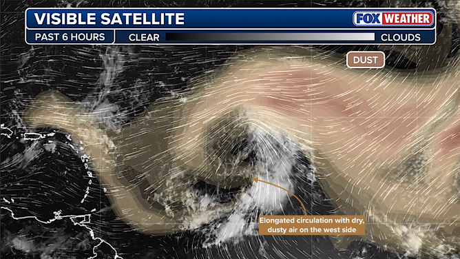
This image shows Saharan dust over the Atlantic Ocean.
(FOX Weather)
The system is expected to eventually push off the hostile conditions and develop into Tropical Storm Gabrielle as soon as later today, but it has some work to do.
There is a strong consensus among the computer forecast models that the system will turn north well before it gets to the Caribbean islands. Extra high surf on the north and east sides of the islands is possible beginning late Friday or early Saturday, however.
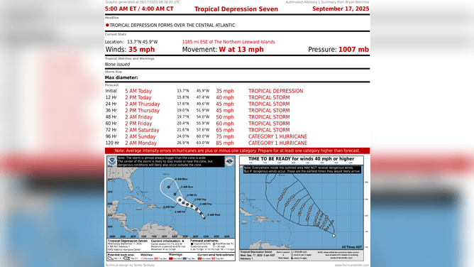
This graphic shows information on Tropical Depression Seven.
(FOX Weather)
As it passes the islands, the weather pattern is forecast to be increasingly conducive to the system strengthening. Many of the computer forecasts show Gabrielle becoming a strong hurricane as it moves north and then hooks to the northeast into the open ocean.
The consensus of the latest predictions is that Gabrielle will miss Bermuda to the east, but that’s not yet 100% certain. It looks to make its closest approach to the island next Monday or Tuesday. In any case, if Gabrielle develops into a strong hurricane as forecast, it will produce violent waves in the waters around Bermuda, and some of that energy will make it to the U.S. East Coast next week.
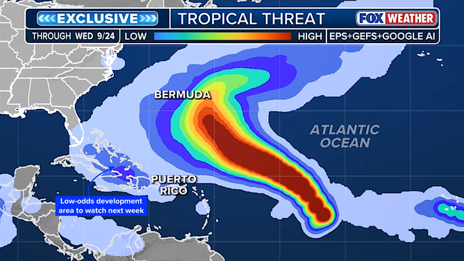
This graphic shows the tropical threat chances from Tropical Depression Seven.
(FOX Weather)
Here is the FOX Weather Tropical Threat analysis that combines the European, the American GFS and the Google DeepMind models.
It shows where likely-Gabrielle is most likely to track over the next week. Notice that the highest odds are just east of Bermuda – with the caveat that all forecasts for disorganized or just developing systems are subject to change.
Also notice the blue area over and south of the Bahamas. That indicates that the combination of the models shows a low, but not zero, probability that a separate system could track that way next week. More below.
What’s up next?
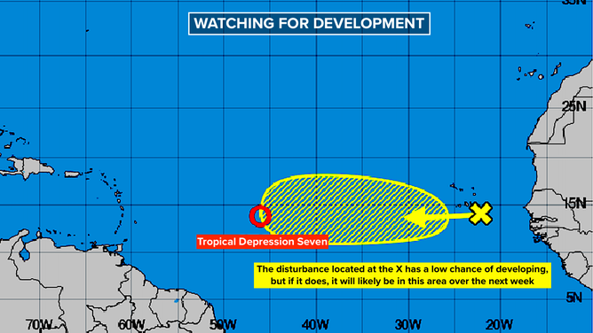
This graphic shows information on development chances for a tropical wave in the Atlantic.
(FOX Weather)
Another tropical disturbance over the far eastern Atlantic is moving west in the general direction of the Caribbean. The National Hurricane Center is giving this one a low chance of developing, and the computer models don’t expect it to do much.
It’s fighting with dry air, but its biggest impediment to development looks to be the strong flow of air coming out of what’s forecast to be Hurricane Gabrielle. If a hurricane is strong, air is rushing in toward the eye. That’s the wind we experience. But that air goes up around the eye and then flows out of the top of the storm. That so-called “outflow” is hostile to other systems that get caught under it.
The consensus of the computer forecasts is that this disturbance will arrive at the Caribbean islands early next week as a gusty moisture surge.
Down the road, this disturbance is likely the one the models are picking up on for possible development near the Bahamas. Again, the odds are low at this point, but it will be something to watch.
There is another disturbance scheduled to come off Africa next week. The latest projections don’t show much development, but of course, we’ll watch that one as well to be sure. In any case, it looks likely to avoid land.
Upper-level winds are forecast to remain hostile to tropical development in the Gulf and Caribbean at least through next week as our unusual hurricane season rolls on.
In the Pacific
Former Tropical Storm Mario has died out, but its moisture is surging north toward California. Dramatically more humid weather will arrive tomorrow as the tropical air pushes from south to north. Heavy rain and some thunder are possible. Stay in touch with local forecasts. The rainy weather is expected to spread over a good part of Southern and Central California, but the rain amounts will vary tremendously from spot to spot.
Some of Mario’s moisture will spread into the Desert Southwest as well, although the core of the tropical air looks more likely to impact California.
Giant South Florida hurricanes
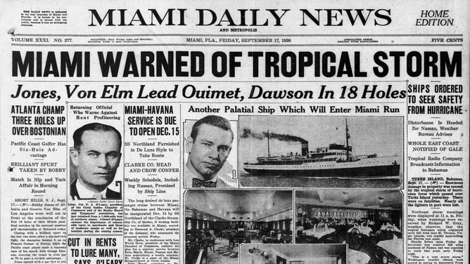
This image shows the Miami Daily News in September, 1926.
(FOX Weather)
This part of September has historically been a time of high impact for giant hurricanes in South Florida.
On Sept. 17, 1926, the afternoon Miami news warned of a tropical storm heading toward the city. At that time, “tropical storms” simply meant a storm originating in the tropics. They knew it was a “severe” hurricane, and it was forecast to arrive that night.
The Miami Herald, which was published in the morning, had said that the storm was likely to miss Florida.
The winds picked up about midnight and blew until the next afternoon. All of South Florida was devastated. The massive hurricane pushed storm surge into downtown West Palm Beach, Fort Lauderdale, across Miami Beach and deep into downtown Miami.
If a storm like the Great Miami Hurricane happened in modern times, it is estimated that it would be the most expensive hurricane in history … by a significant margin.
On Sept. 16, 1928, a huge Category 4 hurricane slammed into West Palm Beach and tracked over Lake Okeechobee. The powerful north winds pushed the broad and shallow lake waters over the dikes protecting the towns to the south. At least 2,500 people died in one of America’s deadliest hurricane disasters.
On its way to South Florida, the great 1928 hurricane plowed across Puerto Rico as a Category 5, taking a track diagonally across the island almost identical to Hurricane Maria’s. It was the worst storm to hit the island in the 20th century.
On Sept. 17, 1947, a large Category 4 hurricane came ashore near Fort Lauderdale, spreading bad weather from south of Miami to north of Palm Beach. The worst of the storm impacted a sparsely populated area that today includes the cities of Boca Raton, Pompano Beach, Coral Springs and many more.
That storm went on to be a devastating hurricane in the New Orleans area as well.