

FOX Weather is your Hurricane HQ.
(FOX Weather / FOX Weather)
Updated Saturday 10 a.m. ET
The National Hurricane Center is painting a large potential development area for the disturbance just moving off Africa. The disturbance is large and ill-defined, but it is showing some signs of a circulation, and it’s carrying a lot of moisture. The strong consensus of the various computer forecasts is that it will continue in the general direction of the Caribbean for most of next week.
Unlike the previous disturbance that was tagged Invest 96L, which is tracking north into the central Atlantic, blocking high pressure will keep this system moving basically east to west for several days.
The big questions are: 1) When will it fight off the dust and dry air sufficiently to develop and organize circulation with sustained thunderstorms, and 2) How will the steering currents evolve next weekend and next week?
The consensus of the various computer forecasts is that a slight dip in the jet stream will weaken the blocking high over the weekend, allowing the developing disturbance to lift north slightly. This will control how close the system comes to the northeastern Caribbean. Most computer forecasts show the system as at least a tropical storm at that time.
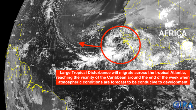
Large tropical disturbance off the western coast of Africa.
(NHC / FOX Weather)
Then after next weekend – too far in the future to be confident – a stronger jet stream dip and its accompanying cold front are forecast to approach the East Coast. The timing and strength of this blocking-high-weakening dip is critical because the strong consensus at the time is that it will turn the system north. It’s too early to know.
How quickly the storm intensifies is important because a stronger tropical system is more likely to be pulled north by the dip because the thunderstorms extend farther up into the atmosphere when the jet-stream steering can grab the storm. On the other hand, a system that develops more slowly would tend to travel farther west before turning north.
Differences in the rate of intensification and the exact depth and nature of the jet stream dip account for the various long-range forecasts you see online. Because the evolution of these details is unknowable, precisely forecasting a track a week or more from now is impossible.
Online posts showing an extreme storm impacting some part of the coast are only there to get clicks. There is no news or information in those single scenario maps.
What we know is that the weather pattern over the Atlantic from the Caribbean islands to the southeast US is forecast to be conducive for the system to organize and strengthen. Enough long-range forecasts show a hurricane developing that we can say with confidence that there’s a good chance we’ll see Hurricane Erin out of this. But since many of the potential tracks turn north offshore of the East Coast, there’s no reason to focus on any one location for impacts.
As we go through next week, if the system becomes better defined like the consensus of the forecasts indicates, we’ll have more confidence in what the computer projections are telling us.
Elsewhere in the Atlantic
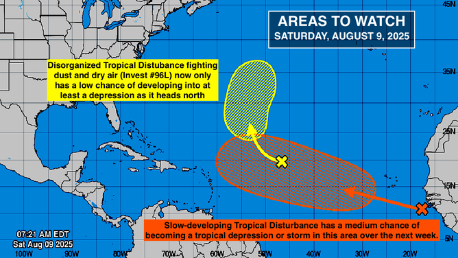
Invest 96L in relation to the tropical disturbance off the western coast of Africa.
(NHC / FOX Weather)
The National Hurricane Center is still tracking Invest 96L. They have lowered the odds into the low range that it will develop into a tropical depression. In any case, it won’t be a threat to land.
The small system offshore of the Carolinas has been absorbed by a cold front and is not a factor.