

FOX Weather is your Hurricane HQ.
(FOX Weather)
Updated at 9:30 a.m. ET on Wednesday, Oct. 8, 2025
Tropical Storm Jerry has run into some hostile upper winds, which has slowed its intensification. The fast-moving system is avoiding the dry and extremely dusty air right on its heels, but the burst of upper winds has pushed all the thunderstorms southwest of the center.
Jerry is still forecast to reach hurricane strength tomorrow before it passes over or near the northeastern Caribbean islands – the Leeward Islands – late in the day or on Friday.
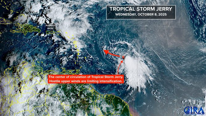
This satellite image shows Tropical Storm Jerry in the tropical Atlantic Basin on Oct. 8, 2025.
(FOX Weather)
The National Hurricane Center is forecasting Jerry to be at Category 1 strength when it is in the vicinity of the northeastern Caribbean given the somewhat hostile conditions.
Although, when a Cat 1 is forecast, we always prepare for at least a Cat 2.
Tropical Storm Watches are in effect for a number of the islands. Direct impacts could be felt from east of the Virgin Islands around to about Guadeloupe.
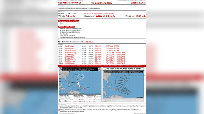
This graphic shows the latest information on Tropical Storm Jerry.
(FOX Weather)
The storm is being propelled by a strong high-pressure system over the eastern Atlantic. Up until now, the computer models seem to have underestimated the strength of that system. The updated tracks have inched closer to the islands. Everyone there needs to stay well-informed.
Even once likely-Hurricane Jerry pulls away to the north on Friday, a strong tail of moisture looks likely to impact the islands, including Puerto Rico, until about Monday. Heavy tropical rains could cause flooding. Stay aware of local alerts.
East Coast storm
A strong fall cold front will push off the Southeast coast tomorrow. By Friday, a non-tropical low-pressure center is forecast to develop along the front – in the winter we’d call it a nor’easter. North of that low, the winds will be strong, pushing the ocean water hard against the coast. Already extra-high tides will be higher than normal.
The persistent onshore winds don’t allow the water to run back into the ocean like it normally would, so coastal erosion is likely. The channel of strong winds will impact North Carolina and Virginia Friday into Saturday and move up the coast, affecting the Delmarva, the Jersey Shore, the Northeast and New England late in the weekend and early next week.
This is an evolving situation. Be aware of the potential for coastal flooding from the Southeast through the mid-Atlantic at least, and stay aware of local alerts for flooding due to heavy rain falling over the coastal sections.
In the Southern Gulf
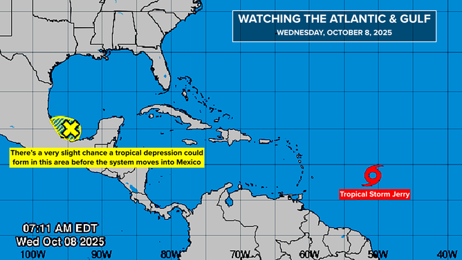
This graphic provides an overview of the tropical Atlantic Basin on Oct. 8, 2025.
(FOX Weather)
The National Hurricane Center is painting a small lemon in the extreme southern Gulf of Mexico. A large disturbance is moving over Central America, including southern Mexico. The top edge of the disturbance is sticking into the Gulf. The odds of even a tropical depression developing in that area are very low.
The southern part of the disturbance is more robust. It looks likely that Tropical Storm Raymond will form from the cluster of thunderstorms close to the Mexican coast.