

FOX Weather is your Hurricane HQ.
(FOX Weather)
Updated on Oct. 3, 2025 at 9 a.m. EST
The National Hurricane Center is highlighting two areas for potential development. The area near Florida and the Bahamas is related to the front that is causing the stormy weather pattern over the Florida peninsula. The area in the eastern Atlantic is related to a robust disturbance just coming off Africa.
The one we’ll watch most closely is the disturbance just moving off Africa.
HOW TO WATCH FOX WEATHER
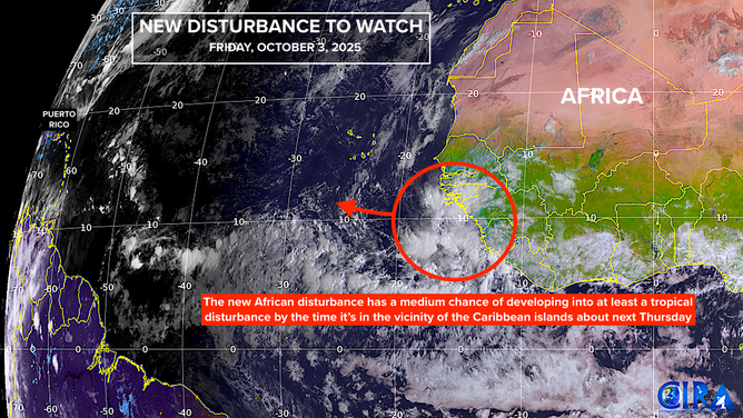
This is satellite imagery of a tropical wave emerging off Africa.
(CIRA / FOX Weather)
Into next week, all of the computer forecasts that predict development, indicate that it will happen slowly. About next Thursday, however, when the system, if it develops, will be in the general vicinity of the Caribbean islands, some forecasts show it intensifying.
Long-range predictions more than a week out have been all over the place – from the Caribbean to the middle of the Atlantic and from a strong storm to nothing. Although most computer forecasts show the system turning north.
All forecasts for a system that hasn’t even begun to develop are suspect, of course. We have to wait at least a couple of days to see if there is a hint of an organized system that the models can latch onto.
It would be very unusual for a hurricane to start in the eastern Atlantic and impact the U.S. in October. In modern times, it has only happened once. That was Hurricane Hazel in 1954.
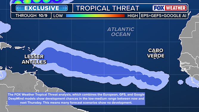
This is FOX Weather’s exclusive Tropical Threat analysis.
(FOX Weather / FOX Weather)
The exclusive FOX Weather Tropical Threat analysis shows the odds of at least a tropical depression forming through next Thursday in the low-medium range.
So let’s see what next week brings.

This graphic shows the tropical Atlantic.
(Bryan Norcross)
The area near Florida
A non-tropical area of low pressure is developing near the Bahamas – along the old front that is stalled across the peninsula. The consensus of the computer forecasts is that it and the front will meander near or over Florida for the next few days. Its time over land and generally hostile upper winds mean it’s unlikely to develop.
Whether it develops or not, a combination of the front and an upper-level low pressure system will keep the rainy pattern in place at least through the weekend.
Long-range forecasts show a real cold front finally changing the weather pattern over Florida around the middle of the month, which could usher in the dry season. We’ll see.
Along the Southeast coast
Another ingredient in the very wet weather pattern over Florida is the strong wind blowing off the ocean. That wind is pushing the seawater up against the coastline from Florida to the Carolinas. The entire ocean is still somewhat energized by ex-hurricanes Humberto and Imelda as well.
The wind is a product of high pressure from Canada that built in over the western Atlantic behind the hurricanes. The high seas and strong currents will only slowly subside into next week.
Beware of dangerous rip currents at the beach. Low-lying coastal areas may experience high-tide flooding from a combination of the elevated water from the wind and the astronomical cycle. Remember, the flooding will be salt water, so don’t drive through it. Your car will thank you.