Close Menu

    Subscribe to Updates

    Get the latest creative news from FooBar about art, design and business.

    What's Hot

    Mass power outage in Spain and Portugal: the surge at the center of the European investigation

    October 4, 2025

    Real Estate Newsletter Articles this Week: Case-Shiller House Prices up 1.7% YoY

    October 4, 2025

    Djed Spence opens up on becoming England’s first-ever Muslim footballer

    October 4, 2025
    Facebook X (Twitter) Instagram
    Facebook X (Twitter) Instagram Vimeo
    Daily Western
    Subscribe Login
    • Western News
      • Culture
      • Politics
      • Economy
    • Sports
      • Football
      • basketball
    • Weather
    Daily Western
    • Home
    • About Us
    • Contact Us
    • Privacy Policy
    Home»Weather»Bryan Norcross: Gabrielle brushing Bermuda as long-range forecasts show more storms likely
    Weather

    Bryan Norcross: Gabrielle brushing Bermuda as long-range forecasts show more storms likely

    DailyWesternBy DailyWesternSeptember 22, 2025No Comments4 Mins Read
    Facebook Twitter Pinterest LinkedIn Tumblr WhatsApp VKontakte Email
    Bryan Norcross: Gabrielle brushing Bermuda as long-range forecasts show more storms likely
    Share
    Facebook Twitter LinkedIn Pinterest Email


    FOX Weather is your Hurricane HQ

    FOX Weather is your Hurricane HQ

    (FOX Weather)

    Updated at 9:45 a.m. ET on Monday, Sept. 22, 2025

    Hurricane Gabrielle will make its closest approach to Bermuda later today. The center is forecast to track more than 150 miles offshore, but the storm will cause large, dangerous swells to impact the island. Winds are not expected to be dangerously strong.
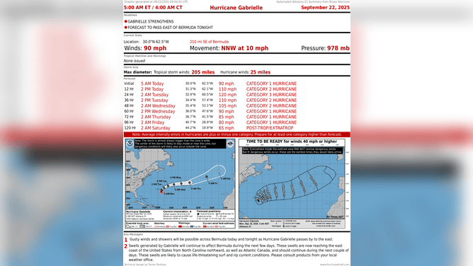
    This graphic shows information on Hurricane Gabrielle.

    This graphic shows information on Hurricane Gabrielle.

    (FOX Weather)

    Some swells are reaching the U.S. East Coast. The ocean will begin to calm down tomorrow as Gabrielle accelerates into the open ocean. The Azores Islands off Portugal will have to keep an eye on it for later in the week.

    Developing tropical disturbances
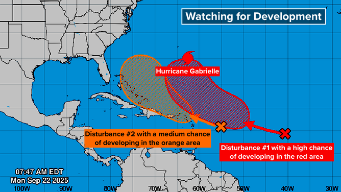
    This graphic provides an overview of the tropical Atlantic Basin.

    This graphic provides an overview of the tropical Atlantic Basin.

    (FOX Weather)

    The National Hurricane Center reintroduced a disturbance we were watching last week – the orange X on the map. I’m calling it Disturbance 2, just to keep them straight. This was the one we were concerned about because it was forecast to move farther west and perhaps turn north in a threatening way.

    Orange means that the NHC is giving the system a medium chance of developing into a tropical depression over the next several days. There is no consensus in the various computer forecast models on what’s going to happen, but many options include the system organizing. The possibilities range from a significant threat to the Southeast to little if any development.

    Disturbance 2 disappeared from the map late last week because the dry air obliterated its clouds and thunderstorms, and it was impossible to follow. The energy from the disturbance continued west, however.

    Now, thunderstorms have redeveloped, and the computer forecast models are tracking the system once again.
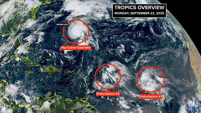
    This satellite image shows Hurricane Gabrielle and two tropical disturbances that could develop over the next week.

    This satellite image shows Hurricane Gabrielle and two tropical disturbances that could develop over the next week.

    (FOX Weather)

    Another change since last week is that now there is a strong consensus that a sharp dip in the jet stream is going to plunge into the Southeast this week. The jet stream dip will tend to keep any storms that try to get near the U.S. East Coast offshore and push them off to the north … at least through this week.

    About next weekend, things get murky, however. There is wide disagreement in the long-range forecasts on how the pattern will evolve, and where Disturbance 2 will be in several days.

    Will it be pulled north, or will it be blocked? Will it develop? Or will it track close to Disturbance 1 and be weakened by the interaction? If it stays weak, it could track into the Caribbean and be pulled north from there.

    That’s all nearly a week away. Obviously, a lot can change in that time. For now, we just have to watch and be aware that something annoying could develop with this system around the weekend.

    The red X represents Disturbance 1, a large disturbance with a high chance of developing. For now, that system is embedded in dust and dry air.

    As indicated by the large red potential development area, it’s not clear when it will pull itself free, but it’s likely to develop. Many forecasts show it becoming a strong hurricane that, more or less, follows Gabrielle in the general direction of Bermuda.
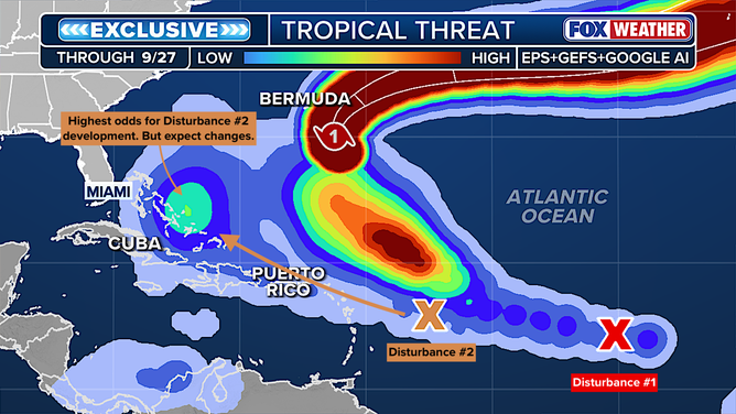
    This graphic shows the tropical threats in the Atlantic.

    This graphic shows the tropical threats in the Atlantic.

    (FOX Weather)

    The exclusive Tropical Threat analysis looks for a consensus among the European, U.S. GFS and Google DeepMind AI models on where or if systems will develop into at least a tropical depression. You can see that there is high agreement that Disturbance 1 will head north following Gabrielle. For Disturbance 2, the consensus is in low to medium range that a system will develop near the Bahamas. But there is a lot of spread in the possible tracks.

    The next two names on the list are Humberto and Imelda. Chances are we’ll use Humberto, and maybe both.

    Bermuda brushing Bryan forecasts Gabrielle LongRange Norcross Show storms
    Share. Facebook Twitter Pinterest LinkedIn Tumblr WhatsApp Email
    Previous ArticleYes, ACA subsidies cut and premium rise could mean your health insurance bill goes up 75%
    Next Article Cooper Flagg emerges as clear Rookie of the Year favorite in ESPN poll
    DailyWestern
    • Website

    Related Posts

    King Tide event enhancing coastal flooding threat along Southeast

    October 4, 2025

    Bryan Norcross: Watching for a Threat to the Caribbean Next Week

    October 4, 2025

    Bryan Norcross: Tropics calming down after Imelda battered Bermuda

    October 4, 2025

    Bryan Norcross: Imelda departs and now two areas to watch in the tropics

    October 3, 2025
    Leave A Reply Cancel Reply

    Demo
    Our Picks

    Richard Jefferson picks Karl Malone over Charles Barkley

    August 5, 2025
    • Facebook
    • Twitter
    • Pinterest
    • Instagram
    • YouTube
    • Vimeo
    Don't Miss
    Politics

    Mass power outage in Spain and Portugal: the surge at the center of the European investigation

    By DailyWesternOctober 4, 20250

    by AI | 03.Oct 2025 | Europe in brief AI The investigation by European experts…

    Real Estate Newsletter Articles this Week: Case-Shiller House Prices up 1.7% YoY

    October 4, 2025

    Djed Spence opens up on becoming England’s first-ever Muslim footballer

    October 4, 2025

    Giannis Antetokounmpo Rejoins Bucks Training Camp Participates In Non Contact Work

    October 4, 2025

    Subscribe to Updates

    Get the latest creative news from SmartMag about art & design.

    About Us
    About Us

    Welcome to Dailywestern.news your reliable source for real-time updates on Western affairs, sports highlights, and global weather insights.

    Our Picks

    Ro Khanna on Elon Musk, Donald Trump, and China

    June 5, 2025

    How the Trump-backed policy bill rolls back Obamacare

    June 5, 2025

    Greg Mankiw’s Blog: Stanley Fischer

    June 5, 2025
    New Comments
      Facebook X (Twitter) Instagram Pinterest
      • Home
      • About Us
      • Contact Us
      • Privacy Policy
      © 2025. All Rights Reserved by Dailywestern.

      Type above and press Enter to search. Press Esc to cancel.

      Sign In or Register

      Welcome Back!

      Login to your account below.

      Lost password?