Close Menu

    Subscribe to Updates

    Get the latest creative news from FooBar about art, design and business.

    What's Hot

    Newcastle vs Tottenham Highlights and Goals

    October 30, 2025

    Pelicans’ Willie Green on hot seat after 0-4 start

    October 30, 2025

    Bryan Norcross: Devastation in Jamaica, Cuba and Haiti as Melissa swipes at Bermuda tonight

    October 30, 2025
    Facebook X (Twitter) Instagram
    Facebook X (Twitter) Instagram Vimeo
    Daily Western
    Subscribe Login
    • Western News
      • Culture
      • Politics
      • Economy
    • Sports
      • Football
      • basketball
    • Weather
    Daily Western
    • Home
    • About Us
    • Contact Us
    • Privacy Policy
    Home»Weather»Atlantic tropical disturbance to bring gusty downpours to the Caribbean Islands Sunday
    Weather

    Atlantic tropical disturbance to bring gusty downpours to the Caribbean Islands Sunday

    DailyWesternBy DailyWesternOctober 18, 2025No Comments3 Mins Read
    Facebook Twitter Pinterest LinkedIn Tumblr WhatsApp VKontakte Email
    Atlantic tropical disturbance to bring gusty downpours to the Caribbean Islands Sunday
    Share
    Facebook Twitter LinkedIn Pinterest Email


    A tropical wave located southeast of the Lesser Antilles is slowly moving through warm Caribbean waters, avoiding strong winds that would make for a hostile environment. The National Hurricane Center said odds for development are still low over the next week.

    A tropical wave located southeast of the Lesser Antilles is slowly moving through warm Caribbean waters, avoiding strong winds that would make for a hostile environment. The National Hurricane Center said odds for development are still low over the next week.

    Updated Saturday 10 a.m. ET

    The Tropical Disturbance we’ve been watching is on track to move across the southeastern Caribbean islands – the Windward Islands – tomorrow into Monday. Gusty squalls with heavy rain are likely in some areas. Then next week, things get fuzzy.

    About Thursday, the system will be in the central Caribbean under atmospheric conditions reasonably conducive to organization and strengthening. The question is, how strong can it get and how quickly?

    A sharp dip in the jet stream will move offshore of the U.S. East Coast late next week. If the system is reasonably strong at that time, the jet stream dip could scoop it up and pull it over Puerto Rico or the nearby islands. But if it stays on the weaker side or forms farther south in the Caribbean, the jet stream dip will more likely miss it, and the storm will meander over the extra-warm Caribbean waters. If the system doesn’t develop much, the jet stream dip could also stretch it into a moisture smear across the northern Caribbean islands.
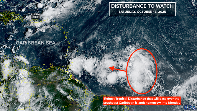
    There is another complicating factor that could affect the disturbance’s ability to organize. A separate disturbance could develop in the southern Caribbean out of a large low-pressure area over Central America – the Central American Gyre (CAG) that we talked so much about last year because it spawned Helene.  The long-range computer forecasts are all over the place as they try to reconcile the dual potential-development areas.

    In any case, we’re talking about more than a week from now, so obviously uncertainty is intrinsically high.

    The bottom line is that the odds of the system affecting the mainland U.S. are very low. The only imaginable scenarios are beyond our ability to forecast. Residents in Puerto Rico and the surrounding islands should plan to pay attention next week. And, of course, there’s a potential impact in Central America as well.

    Unfortunately, it’s going to be a while before we have confidence in the forecast. It’s always this way with disorganized or slow-moving systems, and this one is forecast to essentially stall from the middle to at least the end of next week. And then there’s the potential CAG system in the mix. Stay tuned.

    Farther North in the Atlantic

    Well offshore of the Mid-Atlantic and south of Atlantic Canada, a large and powerful non-tropical storm has a very slight chance of becoming tropical enough to get a name in the next day or two. It will be tracking over relatively warm water associated with the Gulf Stream.
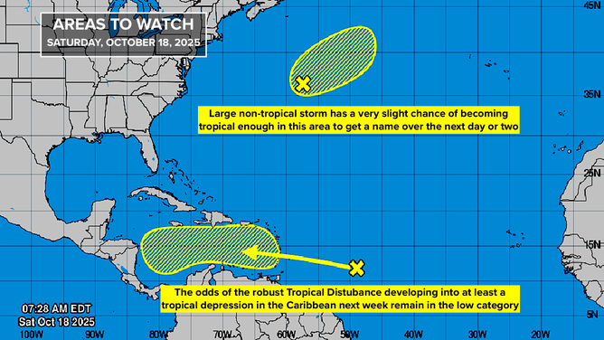
    It’s not a direct threat to land, but it is generating strong swells, which will produce dangerous currents along East Coast beaches from Canada to Florida.

    The next two storm names on the list are Melissa and Nestor.

    75 Years Ago Today

    Around midnight on October 18, 1950, Hurricane King roared through Biscayne Bay and into Miami. It was a minuscule, but fierce storm. The modern estimate is that sustained winds peaked at 130 mph.
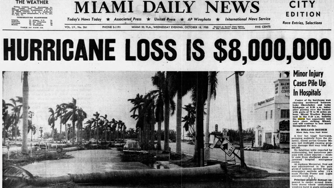
    The storm was so small that the core of the storm passed between downtown Miami and the airport – a distance of only about 6 miles. King was characterized as a giant tornado.

    King was the sixth hurricane of the 20th Century to move over downtown Miami. One more would come in 1964.

    Atlantic bring Caribbean disturbance downpours gusty Islands Sunday tropical
    Share. Facebook Twitter Pinterest LinkedIn Tumblr WhatsApp Email
    Previous ArticlePresident Donald Trump said he’s the first US president to solve a war. Pants on Fire!
    Next Article Lakers waive Marciulionis, Davis, Williams, and Watson
    DailyWestern
    • Website

    Related Posts

    Bryan Norcross: Devastation in Jamaica, Cuba and Haiti as Melissa swipes at Bermuda tonight

    October 30, 2025

    Hurricane Melissa death toll climbs as Jamaica continues recovery operations after catastrophic impacts

    October 30, 2025

    Bryan Norcross: Stunning and record-breaking Melissa mauls Jamaica

    October 30, 2025

    Hurricane Melissa charges on toward Bermuda after leaving deadly path in Caribbean

    October 29, 2025
    Leave A Reply Cancel Reply

    Demo
    Our Picks

    Richard Jefferson picks Karl Malone over Charles Barkley

    August 5, 2025
    • Facebook
    • Twitter
    • Pinterest
    • Instagram
    • YouTube
    • Vimeo
    Don't Miss
    Football

    Newcastle vs Tottenham Highlights and Goals

    By DailyWesternOctober 30, 20250

    League Cup8:00 PMOctober 29, 2025Round 4Referee: Chris Kavanagh, England Copy and paste this HTML code…

    Pelicans’ Willie Green on hot seat after 0-4 start

    October 30, 2025

    Bryan Norcross: Devastation in Jamaica, Cuba and Haiti as Melissa swipes at Bermuda tonight

    October 30, 2025

    Spain will require preserving the decarbonization calendar in the EU at the next Council

    October 30, 2025

    Subscribe to Updates

    Get the latest creative news from SmartMag about art & design.

    About Us
    About Us

    Welcome to Dailywestern.news your reliable source for real-time updates on Western affairs, sports highlights, and global weather insights.

    Our Picks

    Ro Khanna on Elon Musk, Donald Trump, and China

    June 5, 2025

    How the Trump-backed policy bill rolls back Obamacare

    June 5, 2025

    Greg Mankiw’s Blog: Stanley Fischer

    June 5, 2025
    New Comments
      Facebook X (Twitter) Instagram Pinterest
      • Home
      • About Us
      • Contact Us
      • Privacy Policy
      © 2025. All Rights Reserved by Dailywestern.

      Type above and press Enter to search. Press Esc to cancel.

      Sign In or Register

      Welcome Back!

      Login to your account below.

      Lost password?