Close Menu

    Subscribe to Updates

    Get the latest creative news from FooBar about art, design and business.

    What's Hot

    The Missing Rules – Econlib

    October 4, 2025

    Full Premier League lineups, TV

    October 4, 2025

    Clippers’ depth raises rotation questions for Tyronn Lue

    October 4, 2025
    Facebook X (Twitter) Instagram
    Facebook X (Twitter) Instagram Vimeo
    Daily Western
    Subscribe Login
    • Western News
      • Culture
      • Politics
      • Economy
    • Sports
      • Football
      • basketball
    • Weather
    Daily Western
    • Home
    • About Us
    • Contact Us
    • Privacy Policy
    Home»Weather»Atlantic invests 93L, 94L could develop behind powerful Hurricane Gabrielle
    Weather

    Atlantic invests 93L, 94L could develop behind powerful Hurricane Gabrielle

    DailyWesternBy DailyWesternSeptember 24, 2025No Comments3 Mins Read
    Facebook Twitter Pinterest LinkedIn Tumblr WhatsApp VKontakte Email
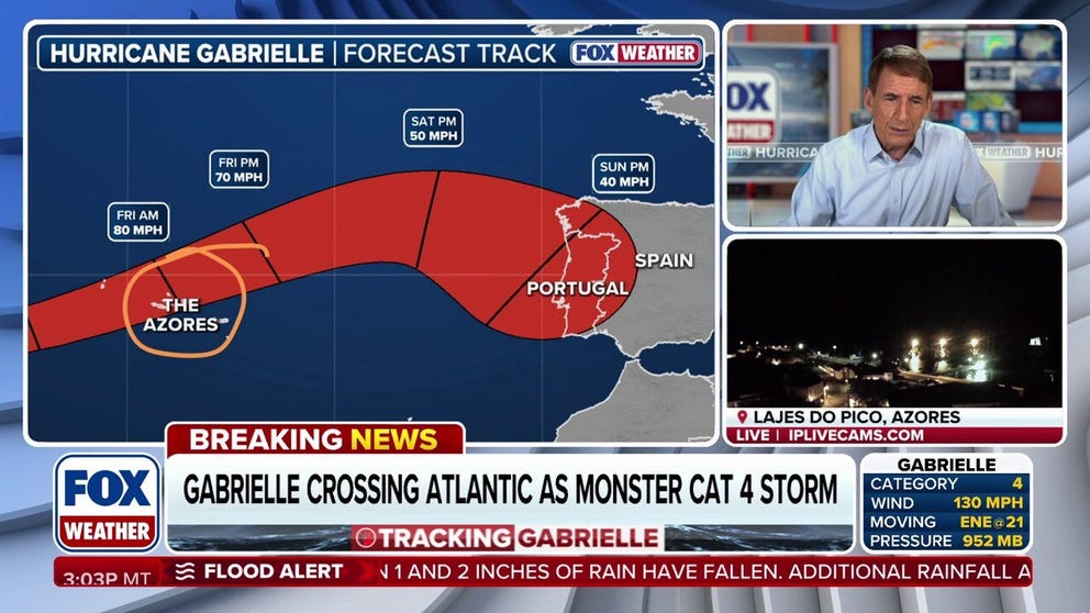
    Atlantic invests 93L, 94L could develop behind powerful Hurricane Gabrielle
    Share
    Facebook Twitter LinkedIn Pinterest Email


    FOX Weather Hurricane Specialist Bryan Norcross provides exclusive analysis on Hurricane Gabrielle and Invest 93L and 94L in the Atlantic. These new developments have potential impacts for Florida, the Southeast and Puerto Rico.

    FOX Weather Hurricane Specialist Bryan Norcross provides exclusive analysis on Hurricane Gabrielle and Invest 93L and 94L in the Atlantic. These new developments have potential impacts for Florida, the Southeast and Puerto Rico.

    MIAMI – The Atlantic Basin is starting to heat up after two new invests were designated for possible development on the heels of powerful Hurricane Gabrielle on Tuesday morning.

    Those invests are now known as Invest 93L and Invest 94L.

    An “invest” is simply a naming convention used by the National Hurricane Center (NHC) to identify areas it is investigating for possible development into a tropical depression or tropical storm within the next seven days.

    HOW TO WATCH FOX WEATHER

    Invest 93L has high chance of becoming tropical depression soon

    This graphic shows information on Invest 93L in the Atlantic.
    (FOX Weather)


    The NHC said shower and thunderstorm activity associated with Invest 93L, located about 750 miles east of the Leeward Islands is continuing to show signs of organization.

    Forecasters say that environmental conditions are expected to be favorable for development over the next several days, and a tropical depression is likely to form over the next couple days while the system moves west-northwestward to northwestward into the western tropical Atlantic Ocean.

    DOWNLOAD THE FREE FOX WEATHER APP

    Puerto Rico, US Virgin Islands urged to monitor progress of Invest 94L

    This graphic shows information Invest 94L in the Atlantic.
    (FOX Weather)


    Invest 94L is also being monitored by the NHC, and this system could move closer to Puerto Rico and the U.S. Virgin Islands.

    The NHC said that Invest 94L is producing a large area of disorganized showers and thunderstorms, as well as some gusty winds, across much of the Windward and Leeward islands.

    “(Invest 94L) is expected to move west-northwestward at 15 to 20 mph, spreading heavy rain and gusty winds into Puerto Rico and the Virgin Islands tonight and Wednesday,” the NHC said.

    Because of the inclement weather on Tuesday, schools across Dominica have been closed.

    Invest 94L is then expected to slow down and make a turn to the northwest when it reaches the southwestern Atlantic near the Bahamas later this week.

    After that, Invest 94L could then strengthen into a tropical depression.

    “Interests in the Virgin Islands, Puerto Rico, the Turks and Caicos Islands and the Bahamas should monitor the progress of this system,” the NHC warned.

    Currently, the NHC is giving the system a low chance of development over the next two days and a high chance of development over the next seven days.

    93L 94L Atlantic develop Gabrielle hurricane Invests powerful
    Share. Facebook Twitter Pinterest LinkedIn Tumblr WhatsApp Email
    Previous ArticleWhy Washington Fixates on AI
    Next Article KJ Martin Waived By Jazz
    DailyWestern
    • Website

    Related Posts

    Bryan Norcross: Watching for a Threat to the Caribbean Next Week

    October 4, 2025

    Bryan Norcross: Tropics calming down after Imelda battered Bermuda

    October 4, 2025

    Bryan Norcross: Imelda departs and now two areas to watch in the tropics

    October 3, 2025

    Winter Storm Watch issued for first time this season in Montana, Wyoming

    October 3, 2025
    Leave A Reply Cancel Reply

    Demo
    Our Picks

    Richard Jefferson picks Karl Malone over Charles Barkley

    August 5, 2025
    • Facebook
    • Twitter
    • Pinterest
    • Instagram
    • YouTube
    • Vimeo
    Don't Miss
    Economy

    The Missing Rules – Econlib

    By DailyWesternOctober 4, 20250

    On my (endlessly expanding) “to-read” list is Nicholas Wade’s book The Origin of Politics: How…

    Full Premier League lineups, TV

    October 4, 2025

    Clippers’ depth raises rotation questions for Tyronn Lue

    October 4, 2025

    Bryan Norcross: Watching for a Threat to the Caribbean Next Week

    October 4, 2025

    Subscribe to Updates

    Get the latest creative news from SmartMag about art & design.

    About Us
    About Us

    Welcome to Dailywestern.news your reliable source for real-time updates on Western affairs, sports highlights, and global weather insights.

    Our Picks

    Ro Khanna on Elon Musk, Donald Trump, and China

    June 5, 2025

    How the Trump-backed policy bill rolls back Obamacare

    June 5, 2025

    Greg Mankiw’s Blog: Stanley Fischer

    June 5, 2025
    New Comments
      Facebook X (Twitter) Instagram Pinterest
      • Home
      • About Us
      • Contact Us
      • Privacy Policy
      © 2025. All Rights Reserved by Dailywestern.

      Type above and press Enter to search. Press Esc to cancel.

      Sign In or Register

      Welcome Back!

      Login to your account below.

      Lost password?