

FOX Weather Hurricane Specialist Bryan Norcross provides exclusive analysis of Tropical Storm Gabrielle. Gabrielle is encountering hostile conditions for development but according to Norcross, the consensus is the storm will hold together enough to encounter more favorable conditions for development.
Updated at 9:30 a.m. ET on Thursday, Sept. 18, 2025
We’ll be LIVE with another Hurricane Q&A this afternoon at 4 p.m. ET on YouTube, Facebook, TikTok, X, Instagram and LinkedIn. Get your questions ready for me and Deputy Director Jamie Rhome from the National Hurricane Center. See you then!

A live Q&A with Bryan Norcross happening Thursday at 4 p.m. ET.
(FOX Weather)
Tropical Storm Gabrielle does not look like much of a storm. It’s basically a low-level swirl with a few associated thunderstorms. Dry air is being forced into the circulation by hostile upper winds from an upper low to its north. In a few days, the hostile winds are forecast to let up, and the National Hurricane Center is predicting that Gabrielle will intensify into a hurricane.
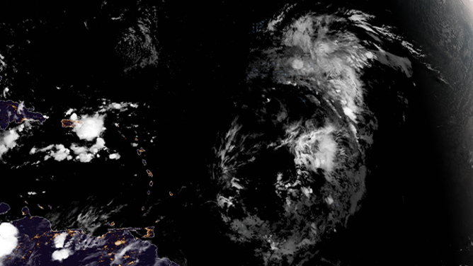
This satellite image shows Tropical Storm Gabrielle on Thursday, Sept. 18, 2025.
(NOAA)
It’s heading in the general direction of Bermuda and looks to approach the island late in the weekend. Shortly thereafter, Gabrielle should move into the strong westerly winds across the North Atlantic and get swept away into the open Atlantic.
The consensus of the various forecast models is that Gabrielle will miss Bermuda to the east, but that’s not 100% certain. The forecasts that maintain Gabrielle as a relatively weak system bring it closer to the island. The more intense the storm becomes, the more likely it is to turn sharply into the North Atlantic, according to the current predictions.
Because the intensity and the track are interrelated, and predicting exactly when the hostile upper winds will let up is key to forecasting the storm’s strength, there is above-average uncertainty in Gabrielle’s potential track near Bermuda. Everybody on the island should stay informed.
Disturbances near Africa
The National Hurricane Center is making note of two disturbances that aren’t far from one another in the eastern tropical Atlantic.
The first one, which moved off Africa on Tuesday, is heading in the general direction of the Caribbean. It’s fighting with dry air and is not currently expected to develop over the next week.
It looks most likely to come near or through the northeastern Caribbean islands in the middle of next week as a moisture surge.
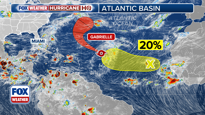
Atlantic tropical overview.
(FOX Weather)
After that time, some computer models, including the new Google DeepMind AI model, and intermittently the European model, show the system becoming part of some kind of development near Cuba or the Bahamas the week after next.
Obviously, it’s far too early to be at all specific. But the fact that they’re increasingly showing the possibility of development may well be a signal that the long-awaited shift toward a less hostile atmospheric pattern will occur about that time.
The bottom line is obvious – there is a lot of hurricane season still to go.
The trailing disturbance just about to move off Africa has a low chance of developing. We’ll watch that one as well. There’s some chance it will continue west as a weak system looking for a patch of atmosphere that’s conducive to development.
As always, forecasts for disorganized or just-developing systems are subject to large errors and likely to change. So don’t get concerned about any long-range projections you might see online. They’ll be different tomorrow.
99 years ago today
On the morning of Sept. 18, 1926, at about 7 a.m., the eye of a monster hurricane made landfall about 14 miles south of downtown Miami – near today’s border between the suburban communities of Palmetto Bay and Cutler Bay. The incredible storm pushed ocean water across Miami Beach and through downtown Miami.
Destruction was widespread. The towns of Hollywood and Dania to the north were substantially destroyed. Damage was heavy throughout Fort Lauderdale. West Palm Beach was flooded.
The raging storm began overnight and lasted into the afternoon on the 18th. The modern estimate is that the storm was a huge 145-mph Category 4 at landfall.
Somehow, the Miami News was able to print one page the morning the storm hit. They used a manual press run by hand since there was no power in the city. The Miami Herald could not publish.
Here is that infamous edition of the Miami News from Saturday, Sept. 18, 1926.
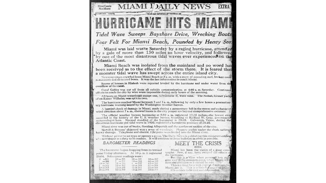
Miami News front page from Sept. 18, 1926.
(Miami News)