

A tropical wave just emerging off Africa has a medium chance of developing in the next week, but conditions in the Atlantic are still somewhat hostile for strong storms.
MIAMI – A tropical wave producing a cluster of showers and thunderstorms just off the coast of western Africa continues to hold the attention of the National Hurricane Center for future development, yet overall, the Atlantic Basin remains unusually quiet for being right at the peak of the hurricane season.
However, some signs are percolating that conditions may become more favorable for storm development closer to home in the weeks ahead.
The tropical wave off Africa is currently shrouded in dry and stable air this weekend, which will likely limit development over the next few days. But the NHC thinks there’s at least a medium chance the system could become a tropical depression by the middle or end of next week, nudging up the odds a little more Saturday morning to a 50/50 chance.

(FOX Weather)
“One limiting factor can really be a big killer for these storms,” says FOX Weather Meteorologist Haley Meier. “And right now, a lot of that has been Saharan dust. Saharan Dust can actually reduce the moisture content within the Saharan air layer by about 50%. And so tropical storms, they are fueled by the warm and moist air… when you have this drier air, you don’t get half of that puzzle.”
Even if the system manages to survive its current encounter with hostile atmospheric conditions, its current prospects for creating mayhem remain low. Extrapolating its current track, it could reach the Caribbean Islands by next weekend, but many forecast models curve the system harmlessly to the north well before then.
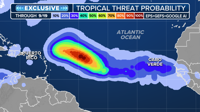
Atlantic Tropical Threat Probability
But the FOX Forecast Center warns that long-range forecasts can always change when attempting to track systems that haven’t even fully developed yet.
Where are the storms?
It’s a bit of deja vu for the Atlantic tropical season, which also underwent several weeks of a lull late last summer as well.
While Hurricane Erin managed to reach Category 5 status as it swirled far off the American shores in August, it is the only hurricane to form so far. And prospects for future hurricanes, at least in the short term, remain dim.
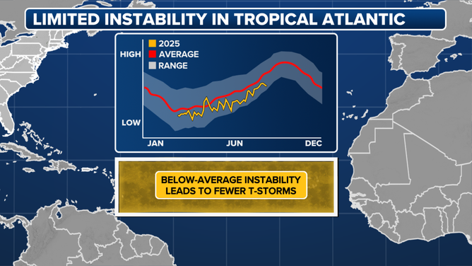
Atlantic Vertical Instability
The FOX Forecast Center notes there are a few factors that could be limiting tropical development. First, there’s been less thunderstorm activity across Africa, with rainfall running below average in August. This is likely tied to the ITCZ — a band of showers and thunderstorms that circle the globe near the equator — shifting north, pushing storms that would normally become future hurricanes and tropical storms into drier, more stable air.
While ocean temperatures in the Main Development Region of the Atlantic remain plenty warm overall, they haven’t been enough to offset poor atmospheric conditions.
“Atlantic Niña” also pumping the brakes on storm development
Also, much like last year’s lull, there is again a pool of relatively cool waters just off the African coast, known as an “Atlantic Niña”. History suggests that it too is an inhibitor of hurricane development.
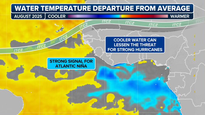
Map showing cooler ocean temperatures off the western African coast, known as an “Atlantic Nina”.
And even when tropical waves survive to make it into the warmer waters to the west, vertical instability has been running below average all season, reducing thunderstorm growth in that main development region.
While the FOX Forecast Center says we don’t know for sure what’s behind this lull, it resembles last year, when activity paused for weeks before picking back up. And it warns that with more than half the season still ahead, there’s plenty of time for things to ramp back up before November.
Increased risk of ‘homegrown’ storms becoming a factor
While the Atlantic remains on the sidelines, forecasters are also watching the return of the Central American Gyre.
WHAT IS THE CENTRAL AMERICAN GYRE?
This is a broad area of low pressure that develops over Central America in the spring and again in the early fall that can produce locally heavy rainfall and can aid in the formation of tropical cyclones.
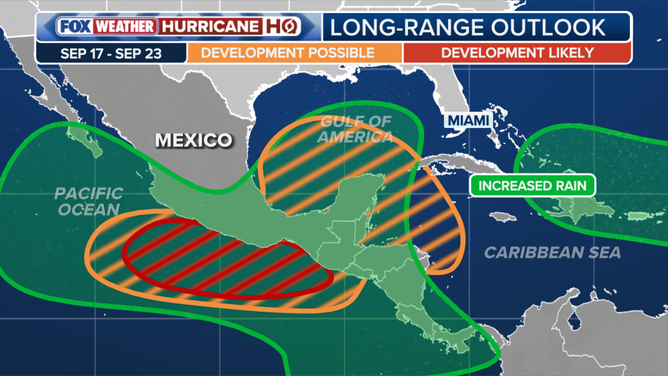
The latest two- and three-week tropical outlooks provided by the Climate Prediction Center highlight this area for potential development into mid to late September.