

FOX Weather Hurricane Specialist Bryan Norcross provides the latest update on Hurricane Erin as it spins some 200 miles off the coast of North Carolina on Thursday morning, April 21, 2025.
Updated at 9:30 a.m. ET on Thursday, Aug. 21, 2025
Hurricane Erin is slowly pulling away from North Carolina. Winds are gusty and tides are elevated, but the worst of the storm stayed right offshore. We’ll still have impacts spreading north to New England. However, whatever happens will peak at the time of high tide along the Northeast coast.
Until Erin accelerates out to sea tonight, the large-diameter storm is putting a tremendous amount of energy into the ocean that will show up at the beaches and waterways along the East Coast as elevated high tides and powerful waves.
The energy emanating from Erin will be felt on most of the East Coast of the U.S., but the focus will be from Cape Hatteras, North Carolina, north to New England.
The elevated ocean level and waves have not challenged the dunes on Cape Hatteras this morning. The highest water levels have been in Pamlico Sound from the persistent north winds blowing the water south. Elevated water around Chesapeake Bay will continue through the day, as well.
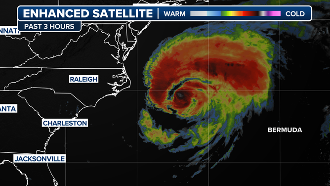
Satellite view of Hurricane Erin off the U.S. East Coast on Aug. 21, 2025.
(FOX Weather)
The peak of the waves and swells from Erin impacting northeastern North Carolina, the Tidewater of Virginia, the Delmarva Peninsula, the Jersey Shore, the coast of Long Island, New York, and the New England coastline looks to be between 7 p.m. and 8:30 p.m. this evening.
It makes a big difference in the Northeast whether the tide is high or low because the water level swings 5 feet or more. The storm will be pulling away from the coast at that time, so while the ocean will be dangerous for swimming, and the waves will be unusually powerful, the impacts should be manageable.
Most beaches along the East Coast will be closed to swimmers through Friday due to the extremely strong and dangerous currents in the water. Be sure to follow any local instructions.
Hurricane Erin is forecast to accelerate out to sea tomorrow. The ocean is still likely to be somewhat disturbed on Saturday, but perhaps not dangerously so. By Sunday, things should be settling down.
3 other systems of note
A relatively large and disorganized tropical disturbance is approaching the northeastern Caribbean islands. The National Hurricane Center is giving it a high chance of eventually developing into a tropical depression or tropical storm.
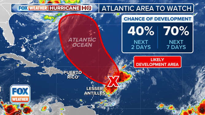
An area to watch in the Atlantic.
(FOX Weather)
The strong consensus of the computer forecast models is that it will not be very strong when it’s in the vicinity of the islands tomorrow or Saturday. It will likely bring some gusty squalls and tropical downpours, however, especially to the Virgin Islands and the islands to the east.
This weekend, a strong fall-like cold front moving off the East Coast and its accompanying dip in the jet stream looks to scoop up that disturbance and direct it to the north. It will most likely track well off the U.S. East Coast, and possibly east of Bermuda as it heads out to sea.
In the tropical Atlantic
The NHC designated the robust disturbance in the eastern tropical Atlantic as Invest 99L. The system is running out of time to develop, however. Hostile conditions are ahead, so if it doesn’t get organized today or tomorrow, it’s lights out. In any case, there is no indication of that system being a threat. It will likely die out in the tropical Atlantic.
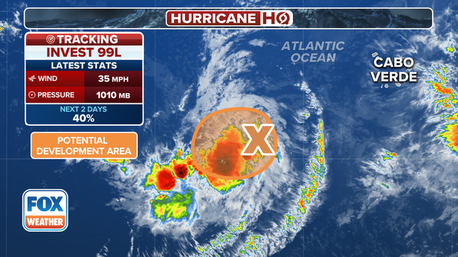
Invest 99L in the Atlantic
(FOX Weather)
If it ever becomes a problem, it will be in the western Caribbean or the southern Gulf in 9 or 10 days.
In the Atlantic
And there’s one more low-odds lemon on the map today. It’s a non-tropical low-pressure system on the tail end of an old cold front. It has a short window of time to develop into a depression before it is swept out to sea. In any case, as with the other disturbances, there is no threat to land.
It looks like we have a lull coming in the tropics that will probably take us into September. Obviously, we watch everything closely this time of year, but it looks like Mother Nature is going to give us a bit of a break.