

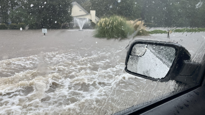
Charleston, South Carolina is already experiencing flash flooding as a stalled cold front hangs over the southeast. Rounds of rain are expected on and off through the weekend.
CHARLESTON, S.C. – A slow-moving frontal boundary that helped protect the Eastern Seaboard from a direct strike by Hurricane Erin is now soaking parts of the South and Southeast, causing widespread flash flooding in Charleston, South Carolina and dampening the weekend for others.
Dozens of roads were closed due to the flash flooding in Charleston, North Charleston and Mount Pleasant, according to National Weather Service storm reports.

Warning boxes are color coded as: Severe Thunderstorm Warnings in yellow, Tornado Warnings in red, Tornado Warnings with confirmed tornado in purple, Flash Flood Warnings in green, and Flash Flood Emergencies in pink.
(FOX Weather)
Charleston International Airport, which received nearly 3 inches of rain in just 35 minutes during one potent thunderstorm, has some roads in front of the international terminals covered in floodwaters and impassable, airport officials reported.
Radar estimated that some communities outside of Charleston saw between half a foot and a foot of rainfall on Friday afternoon.
Dorchester County, which stretches between Charleston and Interstate-95, appeared to be one of the harder hit areas, with several roadways that were impassable.
Dorchester County, S.C. flooding on 8/22/2025.
(Dorchester County Government / FOX Weather)
HOW TO WATCH FOX WEATHER
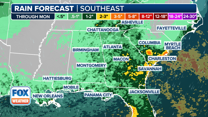
Flash flooding risk expands into Georgia
The front has been slowly cutting south across the East but is running into an atmospheric roadblock as it reaches the Gulf Coast, according to the FOX Forecast Center. And while Hurricane Erin is now racing away from North America, strong flow behind the storm is smashing into the frontal boundary, enhancing the available rainfall.
The greatest risk of flash flooding will stretch from around Charleston through that state’s Low Country and into southeastern Georgia, including Savannah.
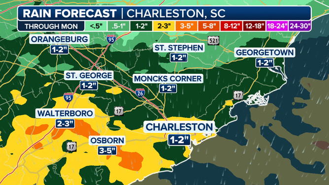
Charleston Area Rainfall Forecast
NOAA’s Weather Prediction Center (WPC) has issued a Level 2 out of 4 flash flood risk for the area, while the National Weather Service has Flood Watches in effect.
With storms lingering into Saturday, rainfall rates there could reach 2-3 inches per hour in heavier and slow-moving thunderstorms, with some storm totals reaching 3-5 inches by later Saturday.
But while the flash flood risk is lower across the rest of the Southeast and Gulf Coast, rainfall totals will still likely reach 1-2 inches through the weekend as the front hangs around.
The WPC is maintaining a Level 1 risk across much of the area for Saturday, but may be upgraded if moisture trends continue to increase, according to the FOX Forecast Center.
Cold front led to Flash Flood Emergency in Virginia
The front has already left its flooding fingerprints in the mid-Atlantic. On Thursday night, flash flooding hit parts of Southwest Virginia and Northern North Carolina where some areas saw nearly 5 inches of rain in just three hours.
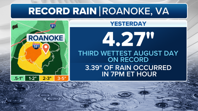
Roanoke, Virginia, received a whopping 3.39 inches of rain in just one hour, triggering a Flash Flood Emergency. The NWS reported nearly a dozen high-water rescues as streets became submerged and vehicles stalled.
The city’s daily rain total of 4.27 inches, which fell in just two hours, was the third-wettest August day in the city’s history and the fourth-wettest date since 1980, the NWS said.
Forecasters there said that corresponded to about a 1-in-500-year flood event, or about a 0.2% chance of rainfall of that magnitude occurring in any given year.