FOX Weather is your Hurricane HQ.
(FOX Weather)
Updated at 11 a.m. ET on Sunday, Aug. 3, 2025
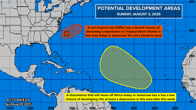
The National Hurricane Center is drawing two areas in the Atlantic where systems could develop. The one off the Carolina coast has a decent chance of being named Dexter over the next day or two. In the middle of the Atlantic, an African disturbance has a chance to develop later this week somewhere in that giant lemon.
Potential Dexter

This graphic shows the development chances of Invest 95L and an area to watch in the Atlantic Ocean.
(FOX Weather)
Once again, a front has stalled along the Gulf Coast extending into the Atlantic off the Southeast coast. This has been a repeating pattern this year. As often happens, an area of low pressure developed along the front. By definition, this is a non-tropical low because it is attached to a frontal system.
As the low-pressure system tracks over the warm Atlantic water, however, it has a medium chance of becoming an independent entity, at which point it would be designated a depression. If winds within the circulation are estimated to be 40 mph, it will be named Dexter.
Sometimes systems like this separate from the front but maintain some of their non-tropical characteristics. That’s when we get so-called subtropical depressions and storms. That’s possible in this case.
The system’s window of opportunity to develop is short. By Tuesday, the upper-level winds are forecast to become hostile, and that should be that. Whatever happens, there is no threat to land.
The old front is forecast to hang around well into next week with areas of low pressure, so-called frontal waves, riding along it. These waves will continue to produce periods of heavy rain along the Southeast coast, across the northern Florida Peninsula, and along the northern Gulf Coast.
In the Atlantic

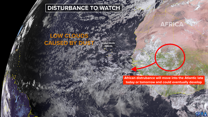
This satellite image shows an area to watch in the tropical Atlantic basin.
(NOAA)
A robust tropical disturbance will move off Africa later today or tomorrow. Forecasts show the system ducking under the large plume of Saharan dust and slowly striking out across the tropical Atlantic. By around Thursday, computer model forecasts show the system’s track beginning to bend to the north as a gap opens in the blocking high-pressure system spread across the Atlantic.
How sharp the turn is, how well the system fights off the dust and dry air, and how it interacts with the evolving steering pattern is an open question. At this point, however, whether it’s a gradual turn or a sharp turn, the strong consensus of the computer forecasts is that the system will turn north before affecting land.
Having said that, this rule is important to remember: All forecasts for just-developing or disorganized systems are prone to large errors and subject to change. And this system hasn’t even moved off Africa yet. At this point, it’s important not to focus on any one prediction.
Many of the computer forecasts indicate that this disturbance will eventually become a tropical storm or hurricane. We’ll see. It will be moving slowly, so we’ll have a long time to watch it.
The most important role of this storm might be to moisten the tropical belt for disturbances coming after it.

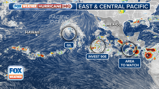
This image provides an overview of the tropical Pacific Basin.
(FOX Weather)
We are still anticipating that the overall weather pattern will become more conducive to tropical development around the middle of August. The Eastern Pacific continues to be very active, although none of the systems appear to be a significant threat to land. The bubble of supportive atmosphere there is forecast to slowly migrate toward the Atlantic. We’ll see.
Looking at the average from 1991 to 2020, the first hurricane doesn’t arrive until Aug. 11. If this African disturbance eventually becomes a hurricane, we will be close to right on schedule for an average season.

