

Areas of the Upper Midwest and Northern Plains are under a severe storm threat Saturday, with damaging winds and large hail as the main threats. Minneapolis and Rapid City, South Dakota are in the level 2 risk.
MINNEAPOLIS — Baseball-sized hail is among the dangerous threats posed by severe thunderstorms expected across parts of the Upper Midwest Saturday, including the Minneapolis-St. Paul area.
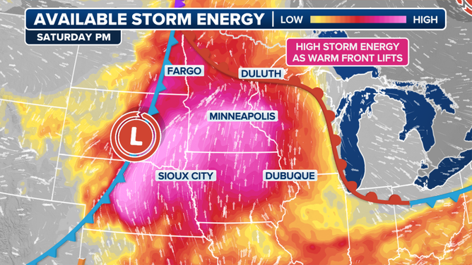
A low pressure system will develop across the northern Rockies and High Plains on Saturday, pulling in moisture from the south into the Dakotas, making the atmosphere quite humid.

Warning boxes are color coded as: Severe Thunderstorm Warnings in yellow, Tornado Warnings in red, Tornado Warnings with confirmed tornado in purple, Flash Flood Warnings in green, and Flash Flood Emergencies in pink.
(FOX Weather)
While some strong thunderstorms were already underway early Saturday morning across the Dakotas, another round of severe weather was expected Saturday afternoon and into the evening as daytime heating will generate high levels of storm energy, according to the FOX Forecast Center.
With the potential for significant atmospheric instability and strong updrafts, there is a risk for very large hail of at least 3 inches in diameter – about the diameter of a baseball, plus damaging wind gusts between 60–80 mph and a few tornadoes.

(FOX Weather)
NOAA’s Storm Prediction Center has issued a Level 2 out of 5 risk of severe weather across the heart of Minnesota, stretching into South Dakota, Nebraska and even western Wisconsin. But the agency has painted an area of significant risk of large hail over the greater Minneapolis-St. Paul metro area.
THE 5-POINT SEVERE THUNDERSTORM RISK CATEGORY SCALE EXPLAINED
Given recent rounds of rain over the past week, flash flooding will also be a concern throughout the weekend.
By Sunday, the severe threat will begin to diminish and shift slightly eastward, the FOX Forecast Center says, with just a narrow stretch of a level 2 risk of severe weather stretching from about Waterloo, Iowa to Green Bay, Wisconsin.
7 THINGS TO KNOW ABOUT HAIL
As the low-pressure system in southern Canada continues moving east, the associated storm activity will shift with it, allowing the region to begin drying out into early next week.
Strong thunderstorms could bring brief damaging wind gusts to Northeast
Meanwhile, those in the Northeast and along the I-95 corridor could see a few rocking thunderstorms as the weekend kicks off.
A line of thunderstorms is expected to roll across Upstate New York and western Pennsylvania starting early Saturday afternoon, sweeping east toward the Interstate 95 corridor by late Saturday evening.

(FOX Weather)
The storms could reach marginally severe levels, with damaging wind gusts up to 60 mph the most likely hazard aside from bursts of heavy rain and frequent lightning.
LIGHTNING SAFETY: WHEN THUNDER ROARS, EVEN TAKING OUT THE TRASH CAN TURN DEADLY
NOAA’s SPC has a Level 1 threat of severe weather for New York City, Philadelphia, Pittsburgh, Washington, D.C. and Baltimore.