
Record heat in the West is helping fuel severe storm threats across the Eastern U.S. this afternoon. Large hail and damaging winds are the main threats, with isolated tornadoes possible. An upgraded Level 3 out of 5 severe storm risk covers parts of the Ohio Valley. FOX Weather Meteorologist Jane Minar walks us through what’s happening:
A fast-moving storm system is expected to sweep across the Eastern U.S. this afternoon and evening, bringing heavy rain and the potential for severe weather through Monday.
A few tornadoes can’t be ruled out in the Ohio River Valley, though the FOX Forecast Center said large hail is currently the primary threat, accompanied by the potential for damaging winds.

Eastern U.S. severe storm threat outlook for Sunday
(FOX Weather / FOX Weather)
Wind intensity could range from 60 mph to over 85 mph in parts of the region.
SPRING STORMS, HEAVY RAIN TARGET THE EAST WHILE WINTER DELIVERS FINAL PUNCH TO NORTHEAST WITH SNOW

(FOX Weather)
This system is being fueled by a massive, record-breaking heat wave in the West, increasing instability ahead of an early spring cold front.
OVER 1,000 RECORDS SHATTERED ACROSS THE SOUTHWEST AS WORST MARCH HEAT WAVE EVER CONTINUES IMPACTING MILLIONS
An upgraded Level 3 out of 5 severe storm risk has been issued for much of western Pennsylvania, eastern Ohio and a small part of West Virginia. Meanwhile, a Level 2 out of 5 severe storm risk remains for Louisville, Kentucky; Cincinnati and Columbus, Ohio.

FILE: Damage left after an EF-1 tornado struck Troy, Ohio on July 23, 2022.
(National Weather Service, Wilmington, Ohio)
FILE: Severe storms early Thursday morning significantly damaged the central Ohio town of Frazeysburg when a tornado swept through the area.
(Frazeysburg, Ohio Police Department)
FILE: A fast-moving and intense weather system has passed through the state, resulting in power outages that AEP Ohio crews worked to fix Wednesday, April 17, 2014. An EF-1 tornado was reported in the Bucyrus area.
(AEP Ohio)
FILE: One woman was killed in Ohio City, Ohio, after a tree fell on her house Wednesday, July 20, 2023.
(Van Wert County EMA)
FILE: A tornado was spotted near Clay Township, Ohio.
(Michael Connolly Thomas)
Heavy rain and thunderstorms will become increasingly likely from the Ohio Valley into southern New England as a cold front associated with a low-pressure system moves into the Great Lakes and Northeast.
CALIFORNIA TIES WARMEST MARCH TEMPERATURE IN US HISTORY FROM HEAT WAVE
And by late Sunday afternoon, that front extending from the system will move into the Ohio Valley, where storms are expected to develop.
As it moves east, the system is expected to affect areas from the Mid-Atlantic coast to the lower Mississippi Valley by Monday morning.
ONGOING EXTREME FLOODING DEVASTATES HAWAII AS POWER RESTORATION CONTINUES, EVACUATION ORDERS LIFT
The FOX Forecast Center said that increasing moisture and atmospheric instability will support storm development, with the potential for damaging winds and hail.

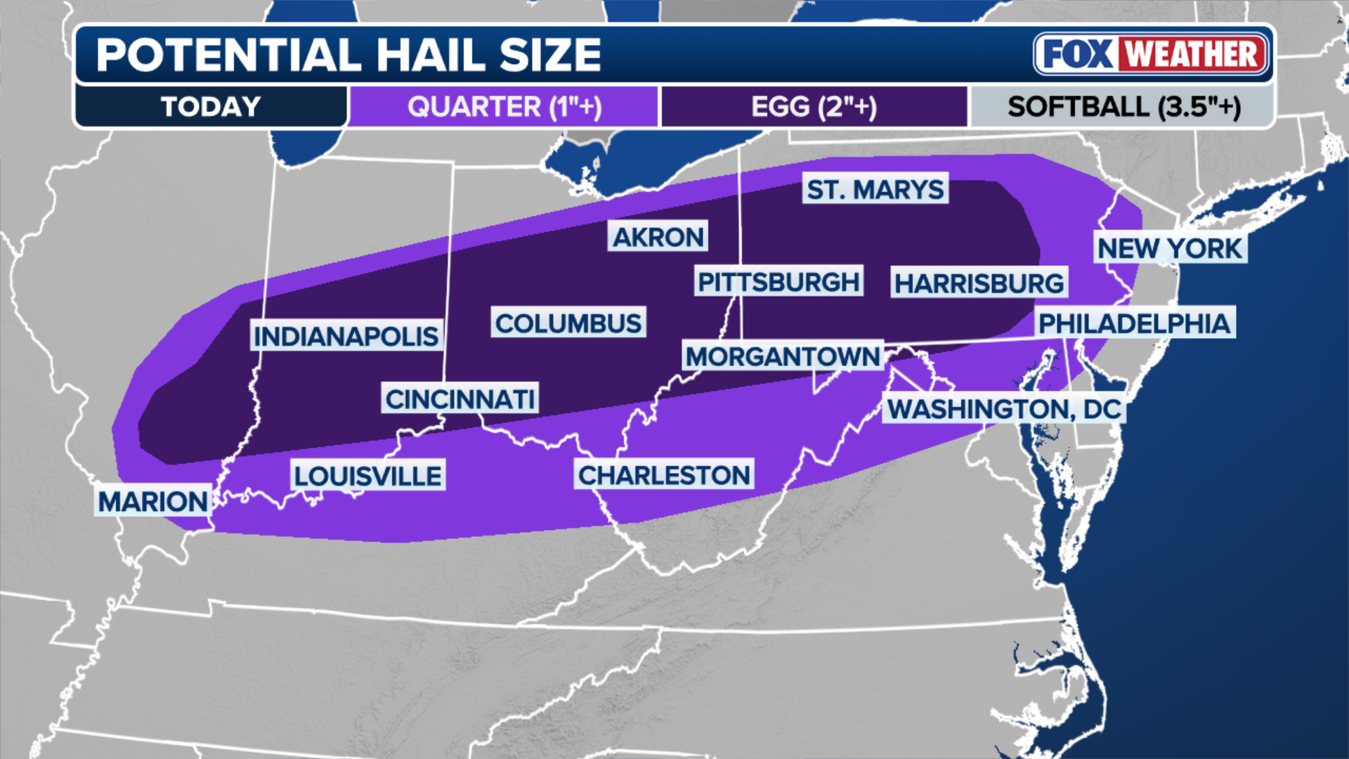
Hail up to 2 inches — or about the size of an egg — is likely in Ohio, West Virginia and Pennsylvania.
(FOX Weather)
However, forecasters note that the warm sector of the system may remain partially capped, which could limit storm development ahead of the front.
KNOW YOUR FLOOD TERMINOLOGY: WHAT FLOOD WATCHES, WARNINGS AND EMERGENCIES REALLY MEAN
If any supercells form and persist, large hail is possible. And while the tornado threat is uncertain, isolated tornadoes cannot be ruled out.

(FOX Weather)
PHOTOS: DEADLY TORNADOES, MASSIVE HAIL, HEAVY RAIN RIP THROUGH MIDWEST, SOUTHERN PLAINS, KILLING AT LEAST TWO
Heavy rain along the front is expected to move into the Mid-Atlantic and southern New England by this evening, with areas from Boston to New York City and Philadelphia potentially seeing occasional torrential downpours into Sunday night.
HOW TO WATCH FOX WEATHER
This has prompted a Level 1 of 4 flash flood threat across Pennsylvania and New York, including Philadelphia, Pittsburgh, and New York City.

(FOX Weather)
By Monday, severe storms could occur across the Carolinas as the cold front begins to weaken, with large hail being the main threat from any severe storms that do develop.