

Six states are under Winter Storm Watches as a powerful nor’easter has its sights set on the East Coast, with the potential to ‘bomb’ out. The Carolinas and Virginia are falling in the bullseye with high-impact snow likely for the areas. The system could also bring winds up to 70 mph and dangerous coastal flooding for the Outerbanks.
A powerful nor’easter is likely to ‘bomb’ out and slam the Carolinas just days after a massive winter storm carved a 2,300-mile path through the United States and brought life-threatening ice and heavy snow to several areas.
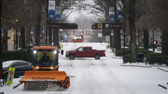
Areas in the Southeast, Mid-Atlantic and Northeast are still working to dig out after receiving significant snow over the weekend. At least 60 deaths have already been reported across 16 states.
The FOX Forecast Center is forecasting a powerful nor’easter to develop off the East Coast this weekend, which has the potential to develop into a bomb cyclone. It is nearly certain that a powerful winter storm will now impact the Carolinas and Virginia. But from there, uncertainty remains regarding where the storm tracks.
ARCTIC PLUNGE: POLAR VORTEX LOCKS IN SNOW, ICE AND LIFE-THREATENING COLD BEHIND HISTORIC CROSS-COUNTRY STORM
Winter Storm Watches have already been issued for North Carolina, South Carolina, Virginia, Maryland, Tennessee and Georgia.
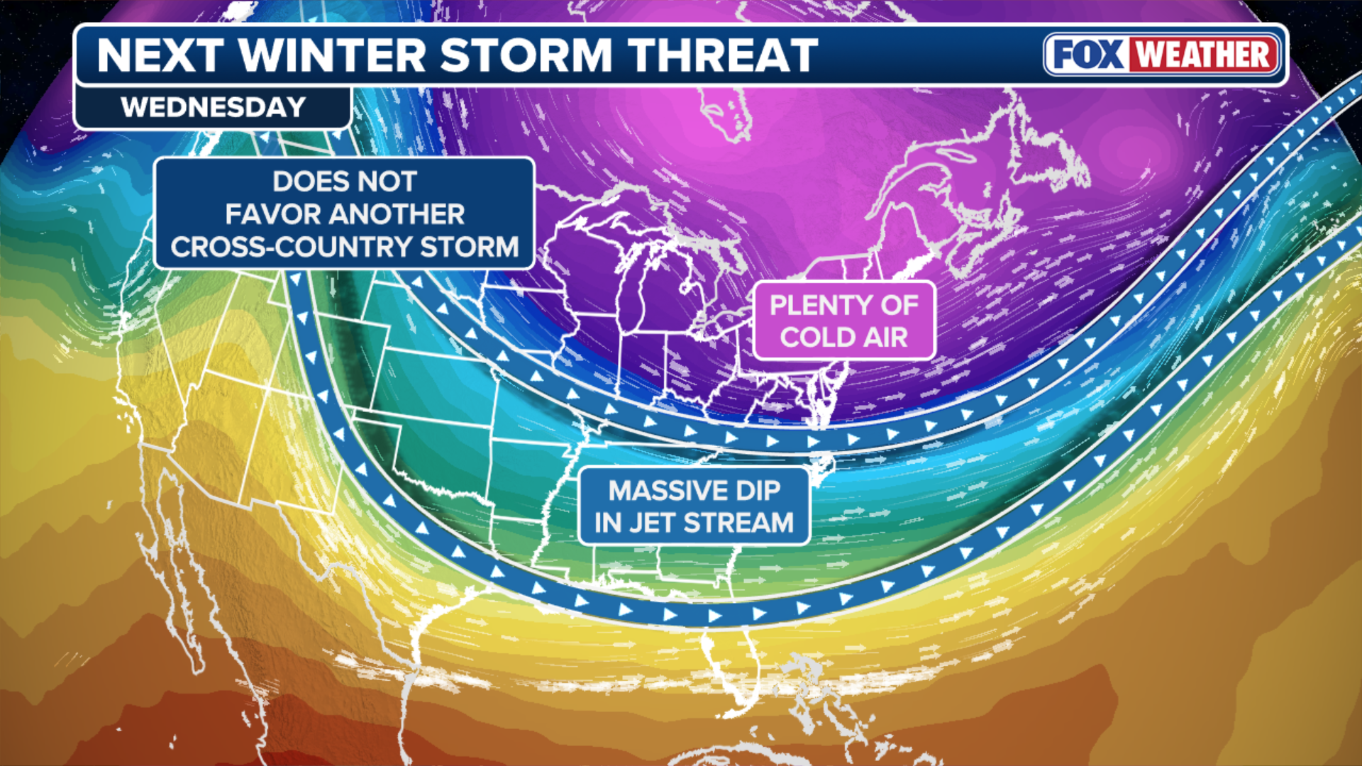
Building the storm
A large reservoir of cold air associated with the Polar Vortex will surge south out of Canada this week and spread across the Great Lakes, eventually making its way into the Southeast.
As this unfolds, the system’s energy will swing through the Southeast and offshore along the East Coast this weekend. This allows very cold air to establish itself across the Mid-Atlantic and the Carolinas.
(FOX Weather)
NOR’EASTER: WHAT CAUSES THESE POWERFUL STORM SYSTEMS?
At the surface, a quickly developing low-pressure system will form just off the Southeast coast along a sharp temperature gradient over the warm waters of the Gulf Stream. As the low strengthens throughout Saturday, it will pull moisture northward while helping to lock cold air in place inland, favoring a long window for heightened winter impacts.
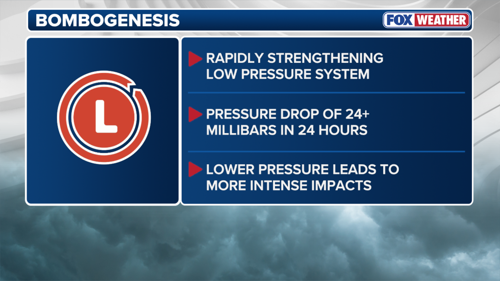
‘Bombing’ out
A notable aspect of this storm is the strong potential for rapid intensification, or ‘bombing’ out.
(FOX Weather)
WHAT IS BOMBOGENESIS?
Bombogenesis occurs when a storm’s central pressure drops at least 24 millibars over a 24-hour window, and current projections suggest this system could deepen from roughly 1,005 millibars to near 967 millibars between late Saturday and midday Sunday.
That level of rapid strengthening would create an extremely tight pressure gradient and result in powerful winds and dangerous conditions along the immediate coastline, particularly across the Outer Banks.
Impacts for the Carolinas, Virginia
Snow will begin during the Friday evening hours.
The system will first develop a bit farther west across the Tennessee Valley and the Appalachians. Impacts on Friday should remain minimal overall, but light snow is possible in places such as Nashville, Gatlinburg and eventually parts of Virginia.
WHAT IS THE JET STREAM?
This phase is more of a lead-in to the main event, rather than the core of the storm.
(FOX Weather)
Come Saturday morning, the story will quickly change. A coastal low will be in the early stages of development, and snow will rapidly stretch across the higher terrain of Virginia, North Carolina, South Carolina and northern Georgia.
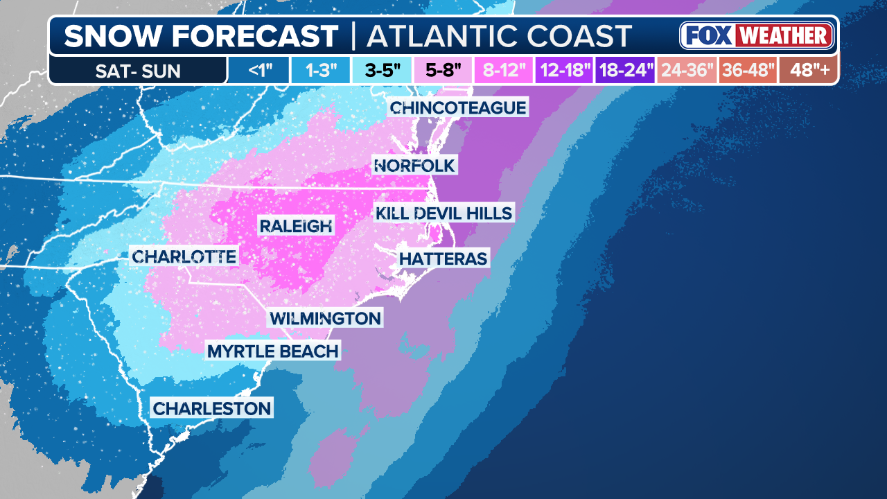
Saturday appears to be the day when the bulk of the snowfall will occur for the region.
As the day goes on, the coastal low will strengthen and pull colder air southward while wrapping in increasing amounts of moisture. Snow intensity is expected to ramp up, especially in interior cities like Richmond, Raleigh, Charlotte and Columbia, South Carolina.
GREENVILLE, SOUTH CAROLINA – JANUARY 25: Crews work to keep Main Street clear as sleet falls January 25, 2026 in Greenville, South Carolina. A massive winter storm is bringing frigid temperatures, ice, and snow to millions of Americans across the nation. (Photo by Sean Rayford/Getty Images)
(Getty Images)
Snowfall rates could become quite high with efficient snow ratios, and this looks to be an all-day event with very few breaks. At this point, a conservative 8–12 inches of snow is on the table, with a bullseye favored for North Carolina, but that total may be understated.
If everything comes together, this system could easily rank as a top-five snow event for cities like Raleigh.

Snow blankets Roanoke, Virginia on Friday, Dec. 5, 2025.
(Jeremy from Roanoke, VA / FOX Weather)
Another conservative bet is widespread 5–8 inches of snow for southern Virginia, the majority of North Carolina and central South Carolina.
While the snowfall will grab most of the attention, some of the most serious impacts will occur along the coast. There is growing concern that the combination of 60–70 mph onshore wind gusts, high surf and significant beach erosion could lead to scenes reminiscent of impacts seen during the recent hurricane season. This includes the potential for the loss of additional homes.
This system is expected to track very close to the coastline, which allows for near hurricane-force gusts in some coastal locations.
-
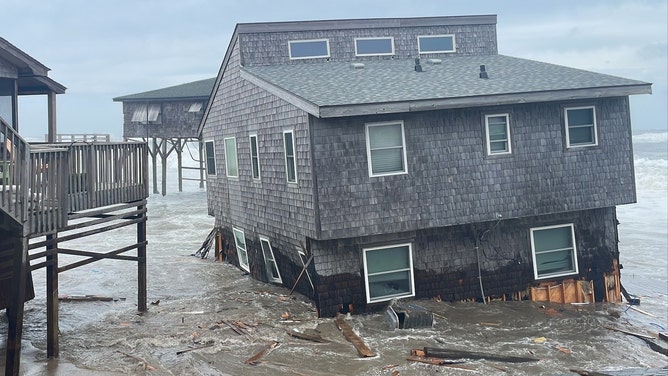
Home collapses in Buxton, N.C. on Sept. 30, 2025.
(Cape Hatteras National Seashore ) -

Home collapse in North Carolina
(National Park Service) -
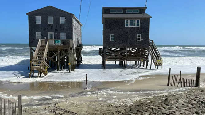
Houses in Rodanthe, North Carolina face the threats of oceans.
(National Park Service ) -

Visitors are urged to stay away from the beach near Rodanthe, North Carolina, following another home collapse due to erosion.
(Jenni Koontz / Epic Shutter Photography) -

Visitors are urged to stay away from the beach near Rodanthe, North Carolina, following another home collapse due to erosion.
(Jenni Koontz / Epic Shutter Photography) -

Visitors are urged to stay away from the beach near Rodanthe, North Carolina, following another home collapse due to erosion.
(Jenni Koontz / Epic Shutter Photography) -

Visitors are urged to stay away from the beach near Rodanthe, North Carolina, following another home collapse due to erosion.
(Jenni Koontz / Epic Shutter Photography)
Snow is likely to reach across areas like Wilmington, Myrtle Beach, Charleston and the Outer Banks.
If the timing of the heaviest snow overlaps with the strongest winds, blizzard conditions cannot be ruled out, especially along the North Carolina coast. Snow totals will taper closer to the shoreline, but 3-5 inches by Sunday morning seems possible.
Boost from the Snow Moon
This storm coincides with a full moon, also known as the Snow Moon, which adds another layer to the threat.
Strong winds are expected to align closely with Sunday morning’s high tide around 7-8am ET. This raises the risk of coastal flooding from storm surge-like water rise. Projections suggest a potential 3–4 foot rise along vulnerable stretches of the coastline. Combined with blowing snow and possible whiteout conditions, the scenes along the coast on Sunday could be striking and potentially severe.
Northeast impacts
Farther north, the FOX Forecast Center is keeping an eye on potential impacts from the Nor’easter on Sunday. Most models agree that the storm will be nearby, but there is strong disagreement on the exact track. At this point, a complete miss seems to be the least likely outcome, and some level of impact is probable.

(FOX Weather)
HOW TO WATCH FOX WEATHER
This system is drawing attention because several model solutions depict a high-impact snowstorm just days after the historic cross-country system. In some scenarios, moderate to heavy snow is possible, particularly from eastern Massachusetts into Maine. Other possibilities keep the bulk of the snow offshore with little accumulation inland.
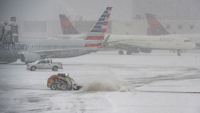
A snow plow works to clear the runways at Logan Airpot in Boston, Massachusetts, on January 25, 2026. A massive winter storm on January 24 dumped snow and freezing rain from New Mexico to North Carolina as it swept across the United States towards the northeast, threatening tens of millions of Americans with blackouts, transportation chaos and bone-chilling cold. After battering the country’s southwest and central areas, the storm system began to hit the heavily populated mid-Atlantic and northeastern states as a frigid air mass settled in across the nation. (Photo by Joseph Prezioso / AFP via Getty Images)
(Getty Images)
Currently, the highest confidence for meaningful impacts is across southeastern Massachusetts, especially Cape Cod, Martha’s Vineyard and Nantucket. Even with a somewhat offshore track, this area could still see snow, strong winds and hazardous marine conditions.
For Massachusetts and Rhode Island, snow will not be the only concern if the storm tracks closer to the coast. A stronger system could produce powerful winds along the immediate coastline and over the waters. Wind gusts could exceed 60 mph across the Cape and Islands, with higher gusts possible. If the strong winds line up with high tide, coastal flooding and beach erosion would become a concern.

NEW YORK, NY – JANUARY 25: A taxi driver clears snow off his cab while stopped at a traffic light on Fifth Avenue during a snowstorm on January 25, 2026, in New York City.
(Photo by Gary Hershorn/Getty Images / Getty Images)
Confidence drops quickly farther west, underscoring how sensitive this forecast is to small shifts.
MISSISSIPPI PARALYZED BY LARGE-SCALE POWER OUTAGES, LIFE-THREATENING ICE AS ARCTIC AIR COULD SLOW RECOVERY
Cities along the Interstate 95 corridor are on the extreme western fringe of the potential impacts. For places like New York City, a difference of 50-100 miles in the storm track could mean the difference between minor and more notable impacts. Currently, the I-95 corridor, from Washington, D.C. to New York City, is not expected to see a blockbuster snowstorm, but some impacts remain possible from gusty winds and periods of light snow.
This is a developing story. Stick with FOX Weather for all the latest forecasts and updates.